
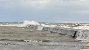
The National Weather Service has issued a Gale Watch for Lake Huron, effective through Monday night, as a strong weather system moves across Michigan. Winds are forecasted to reach 35-40 knots, with gusts potentially exceeding 45 knots. Waves could build to 8-12 feet, making conditions on the lake extremely dangerous for vessels of all sizes.
Mariners are urged to stay off the water during this period, as gale-force winds can capsize boats and create life-threatening conditions. Those along the shoreline should also remain cautious, as high waves could lead to localized flooding and hazardous surf.
The strongest winds are expected Monday afternoon into the evening, especially along the eastern shores of Michigan. These conditions are part of a broader weather system bringing unsettled weather, including rain and potential snow showers, to parts of the state.
Officials recommend securing loose outdoor objects and avoiding shoreline areas during the Gale Watch. Residents are reminded to keep a close eye on weather updates and heed warnings for their safety.
CONCLUSION:
With hazardous winds and towering waves on the horizon, Lake Huron’s Gale Watch serves as a stark reminder of winter’s power. Stay safe, avoid the water, and monitor conditions closely as Michigan braces for this significant weather event.