
Nevada is bracing for a major storm this week, with heavy rainfall, powerful winds, and flood risks threatening multiple regions. The National Weather Service has issued flood watches and severe weather warnings, urging residents to take action and prepare for rapidly changing conditions. The combination of saturated ground and incoming rain is setting the stage for dangerous flash floods, slippery roads, and power outages across the state. Here’s what you need to know to stay safe and prepared.
Current Weather Snapshot
This morning, residents of Las Vegas enjoyed partly sunny skies and temperatures around 57°F (14°C), but don’t be fooled by the calm. The weather is expected to turn quickly. In Reno, it’s already overcast at 45°F (7°C), and rain showers will be moving in throughout the day. As winds pick up and rain intensifies, conditions will worsen, making travel and outdoor activities risky.
The Forecast: What’s Coming
- Tuesday: Las Vegas will see highs near 78°F (26°C), possibly breaking records set in 1953. Winds will increase by the afternoon, and gusts could be strong enough to knock down tree limbs and debris. Reno will experience intermittent rain and breezy conditions, with a high of 56°F (13°C) and a low of 33°F (1°C).
- Wednesday: Conditions will remain breezy, but Las Vegas should stay mostly dry with a high of 74°F (23°C). Reno will start to clear, but gusty winds may persist.
- Thursday: Rain and gusty winds return to Reno, with the possibility of light snow in higher elevations. Roads could become slippery as temperatures dip. Las Vegas will stay warm and sunny, but strong winds may still cause localized issues.
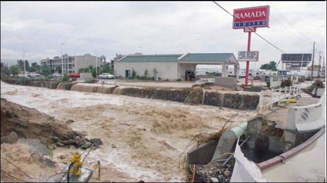
Why This Storm Is Dangerous
Heavy rainfall is expected to overwhelm parts of northern Nevada, where rivers and creeks are already running high. Urban areas could experience flooding on roads and low-lying neighborhoods due to poor drainage. Meanwhile, gusty winds pose a serious threat across the state. Strong gusts could topple trees, blow around unsecured objects, and damage power lines, leading to outages. Officials are urging people to avoid traveling during peak storm periods and to secure any loose outdoor items. Areas near rivers and creeks, especially in and around Reno, will need to watch for rising water levels that could cause flash flooding without warning.

Key Safety Tips for Residents
- Avoid driving on flooded roads: Even if the water doesn’t look deep, it’s dangerous. Just six inches of water can cause a car to stall, and a foot of moving water can sweep a vehicle away.
- Prepare an emergency kit: Include essentials like bottled water, non-perishable food, flashlights, extra batteries, medications, and important documents. Power outages could last for hours, so it’s best to be ready.
- Secure loose items: Bring in patio furniture, trash bins, or any outdoor items that could be blown around by gusty winds.
- Clear gutters and drains: Make sure water can flow freely away from your home to minimize the risk of flooding.
- Stay informed: Monitor local news or weather apps for updates. Sign up for text alerts from the Nevada Department of Public Safety for real-time information.
Flood Watch in Effect
A flood watch is active in northern Nevada, where officials are closely monitoring rivers and creeks. Heavy rain could cause water to rise rapidly, and flash floods are possible in areas with poor drainage. If you live in a flood-prone neighborhood, have a plan in place to evacuate quickly if needed.
Travel and Power Concerns
Road conditions will be hazardous during peak rain and wind events. Flooded roads may become impassable, especially near rivers or drainage systems. Drivers should expect delays and detours. Power companies are on standby, but restoration may take time if outages become widespread due to wind damage. Residents are encouraged to charge their devices and keep backup chargers ready.
Looking Ahead: When Will Conditions Improve?
By Friday, most of the storm system is expected to move out, and drier weather will return for the weekend. Las Vegas will enjoy sunny skies, while Reno will see cooler temperatures but mostly clear conditions. However, another round of rain could develop early next week, so keep emergency supplies on hand and stay prepared.