
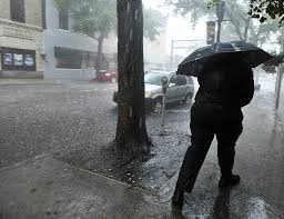
Clay County residents should be on high alert this week as severe weather moves through the area, bringing heavy rain, gusty winds, and possible flooding. The National Weather Service has issued a Flood Watch, warning that rivers and creeks could overflow, roads may become impassable, and power outages are possible as conditions worsen. Local officials are urging everyone to take the storm seriously. With the ground already saturated from previous rainfall, even a few more inches of rain could cause dangerous flooding in low-lying neighborhoods. Here’s what you need to know to stay safe.
The Calm Before the Storm Ends Today
This morning, Clay County is starting with overcast skies and cool temperatures around 44°F (7°C). It’s a quiet start to the day, but forecasters warn that conditions will change quickly. By the afternoon, heavy rain will move in, and winds will start to pick up. The high temperature will hit 55°F (13°C), but the cold rain and wind will make it feel much chillier. The heaviest rain is expected to fall in the late afternoon and evening, just in time for the evening commute. Roads may become slippery, and standing water could make driving dangerous. If you can avoid traveling, it’s best to stay home.
What to Expect Over the Next Few Days
- Tuesday: Heavy rain and gusty winds will dominate the day. Flooding risks will increase as water collects in streets and low-lying areas.
- Wednesday: The rain won’t let up easily. Expect another cool day with a high of 44°F (7°C) and steady rainfall. Low-lying areas near rivers and creeks could see rising water levels, so keep an eye on local flood warnings.
- Thursday: The storm begins to ease, but light rain and occasional thunderstorms are still possible, especially in the morning. Winds will remain gusty, and roads could still be slick from lingering rain.
Why This Storm Is Dangerous
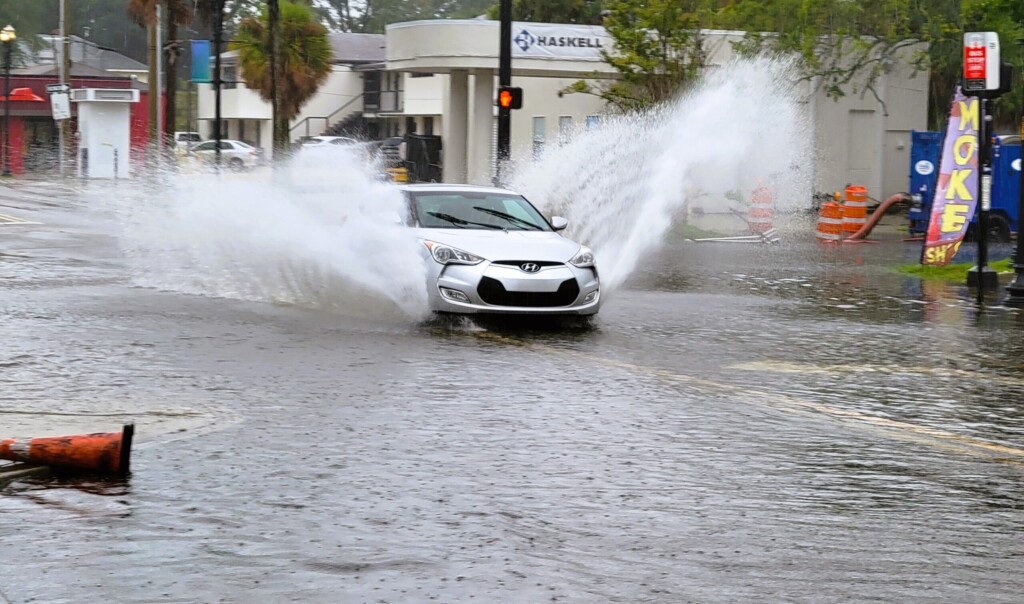
The main concern with this storm is flooding. Clay County’s rivers, creeks, and drainage systems are already full from recent rainfall. With more rain on the way, it won’t take much for water levels to rise quickly. Urban areas with poor drainage are at risk of water pooling in streets, driveways, and basements. Strong winds are another threat. They could knock down trees, damage power lines, and send loose debris flying through the air. If the wind gets bad enough, power outages are possible, especially in rural areas where trees line power routes.
How You Can Stay Safe
- Avoid flooded roads- Even shallow water can be more dangerous than it looks. Just six inches of water can stall your car, and a foot of moving water can sweep it away. Never drive through flooded streets—turn around and find another route.
- Prepare your home- Clear gutters and drains to make sure water can flow freely away from your home. Bring outdoor furniture inside or secure it to prevent damage from high winds.
- Pack an emergency kit- Have essentials on hand, like flashlights, batteries, bottled water, non-perishable food, medications, and important documents. Power outages could last several hours, so be ready to stay safe and comfortable without electricity.
- Stay informed- Monitor weather updates on local news and sign up for alerts from the Clay County Emergency Management system. If an evacuation order is issued, be ready to leave quickly.
- Check on neighbors- If you have elderly or disabled neighbors, give them a call or stop by to make sure they’re prepared.
Expect Travel Delays and Power Issues
Roads in flood-prone areas could become impassable as water levels rise, especially during periods of heavy rain. Major routes, including rural roads near rivers, may be closed due to flooding or fallen debris. If you must drive, go slowly and be on the lookout for hidden hazards like potholes or branches. Power companies have crews ready to respond to outages, but restoration times could vary depending on how widespread the damage is. Charge your phone and other devices ahead of time, and keep backup power sources, like portable chargers, nearby.
Looking Ahead: When Will Things Calm Down?
The worst of the storm should be over by Thursday, with drier weather expected by Friday. The weekend looks much better, with partly sunny skies and calmer winds, giving the community a chance to recover from any damage. However, forecasters warn that more rain could return next week, so keeping emergency supplies ready is a good idea.