
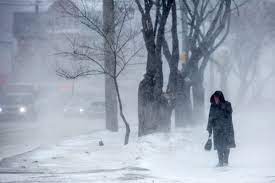
A winter storm is approaching North Dakota, promising heavy snowfall, dangerously cold temperatures, and slippery roads that could disrupt travel plans and daily life. With snow beginning as early as Wednesday afternoon, forecasters are urging residents to take precautions and prepare for hazardous conditions.
Fargo: Snow and Slippery Commutes Incoming
In Fargo, the current temperature sits at a frigid -6°F (-21°C) under mostly cloudy skies. While today will remain cold with occasional flurries, the real impact starts Wednesday afternoon. Snow will begin accumulating around 1 to 2 centimeters (about half an inch), making roads slick and potentially hazardous for commuters. The high temperature for Wednesday will only reach 20°F (-7°C), with lows plunging to 0°F (-18°C) overnight. Residents should be prepared for freezing conditions and icy sidewalks.
Bismarck: Light Snow but Dangerous Cold
Bismarck is also under cloudy skies today, with temperatures hovering around -7°F (-22°C). While today will see minimal snowfall, the cold will continue to grip the city. On Wednesday, Bismarck can expect afternoon snow flurries with accumulations of around 1 centimeter (less than half an inch). But don’t let the seemingly small amount of snow fool you—combined with sub-zero temperatures, roads will still be slick and dangerous. The high on Wednesday will be around 17°F (-8°C), with an overnight low of -4°F (-20°C).

Grand Forks: Moderate Snow to Blanket the Area
Grand Forks is currently sitting at -6°F (-21°C) under clear skies, but conditions will quickly change. Wednesday brings increasing cloud cover and moderate snowfall by the afternoon, with accumulations of 2 to 4 centimeters (about 1.5 inches). Though not extreme, this level of snow can cause dangerous road conditions, especially when paired with the cold. Expect a high of 18°F (-8°C) and a low of -3°F (-19°C) as the bitter chill tightens its grip on the area.
Minot: Heaviest Snowfall Expected Here
Minot is facing the brunt of this winter storm, with temperatures currently at -11°F (-24°C) and cloudy skies. Snow will begin falling today, bringing light accumulations of around 1 to 3 centimeters (up to an inch). But things will escalate quickly on Wednesday, when Minot could see heavy snow accumulations of 6 to 12 centimeters (about 2.5 to 5 inches). Roads are likely to become treacherous, and visibility could be reduced during periods of heavy snowfall. The high temperature will hover around 9°F (-13°C) during the day, with an overnight low of -7°F (-22°C).
What You Need to Do to Stay Safe
- Limit Travel: To reduce the risk of accidents, avoid unnecessary travel during peak snowfall hours. Roads will be slippery, and visibility may be poor in certain areas.
- Keep Your Vehicle Winter Ready: Keep an emergency kit with essentials like blankets, water, snacks, a flashlight, and a phone charger.
- Stay Warm: Dress in layers and wear insulated gear to protect yourself from frostbite in sub-zero temperatures.
- Keep Updated: Check local weather reports frequently for any updates or changes in the storm’s trajectory or severity.
This storm is expected to bring a mix of light to heavy snow across North Dakota. However, due to freezing temperatures, even areas with smaller accumulations could experience dangerous conditions. Be cautious, stay informed, and prioritize safety. The next few days could be challenging, but with the right precautions, you can weather the storm.