
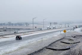
Iowa residents are being warned to prepare for a messy and potentially dangerous Wednesday as freezing rain moves across the state. The National Weather Service has issued a Winter Weather Advisory covering much of the region, starting Wednesday morning and lasting into the evening. Light freezing rain and drizzle are expected to create slick conditions on roads, sidewalks, and bridges, making travel risky.
When and Where the Ice Will Hit
- Southern Iowa: It is predicted that freezing rain will start in the morning and get worse throughout the day.
- Central Iowa: By lunchtime, icy conditions are expected to form and persist into the afternoon.
- Northern Iowa: The worst weather is predicted to occur from midday until approximately nine o’clock at night, when there will be a continuous accumulation of ice.
How Much Ice Will There Be?
Ice accumulation of up to a tenth of an inch is predicted. This may not seem like much, but surfaces can become dangerously slippery even with a thin gloss. Roads are anticipated to be the most dangerous, particularly overpasses and untreated regions.
Potential Impacts on Travel and Safety
With the freezing rain still falling, the evening commute may be particularly challenging. In order to prevent skidding, drivers are urged to reduce their speed, leave more space between cars, and refrain from abrupt braking. Along with the dangers of travel, there is also worry about power outages since ice buildup may cause power wires and tree limbs to become heavy.
What You Can Do to Stay Safe
- Plan Your Travel: If possible, avoid unnecessary trips during peak freezing periods. If you must drive, give yourself extra time and drive slowly.
- Stay Informed: Monitor the latest updates through local weather apps and road condition alerts, such as the Iowa 511 system.
- Prepare for Power Outages: Keep flashlights, extra batteries, and warm clothing ready in case of power loss. Charge your devices and ensure you have enough food and water.
What’s Next?
Temperatures will hover near freezing through the night, meaning icy conditions could persist into Thursday morning. As temperatures gradually warm, the ice should melt by midday Thursday, but early risers may still find slippery sidewalks and driveways.
With a little preparation, Iowans can ride out this storm safely. Stay cautious, stay warm, and be sure to check on elderly neighbors who may need extra help during the icy weather.