
Indiana’s weather is about to take a wild turn, and it’s going to happen fast. This weekend will feel like a weather rollercoaster, with temperatures soaring into the upper 50s in some areas before plummeting below freezing just hours later. Along with this drastic temperature drop, rain, thunderstorms, and possibly even icy roads could make for a messy and unpredictable weekend. The National Weather Service has issued advisories across the state, warning of potential flooding, icy conditions, and hazardous travel. If you have weekend plans, now is the time to prepare for the major shifts ahead.
Friday: A Calm Start Before the Chaos
Before the real action begins, Friday will be relatively mild, though clouds will begin to build ahead of the storm system moving in.
- Indianapolis: Mostly cloudy, high of 38°F (4°C), low of 31°F (0°C).
- Fort Wayne: Intervals of clouds and sunshine, high of 33°F (0°C), low of 26°F (-3°C).
- Evansville: Cloudy with a high of 43°F (6°C), and a low of 39°F (4°C).
- South Bend: Some sun before turning cloudy, high of 33°F (1°C), low of 26°F (-4°C).
If you need to run errands or travel, Friday is your best chance before things take a turn.
Saturday: A Stormy and Dramatic Weather Shift
Saturday starts warm—unusually warm for February. But don’t get too comfortable, because a powerful cold front will move in quickly, bringing rain, thunderstorms, and a drastic temperature drop.
- Indianapolis: Cloudy with rain and thunderstorms throughout the day. High near 40°F (5°C), dropping fast to 28°F (-2°C) overnight.
- Fort Wayne: Rain moving in early, possibly freezing on surfaces as temperatures fall. High of 34°F (1°C), low of 26°F (-3°C).
- Evansville: Very warm for February—high near 59°F (15°C). But don’t let that fool you; temperatures will plummet to 29°F (-2°C) by night.
- South Bend: A messy mix of snow, sleet, and freezing rain developing in the afternoon, accumulating up to 1 cm. High of 34°F (1°C), low of 26°F (-4°C).
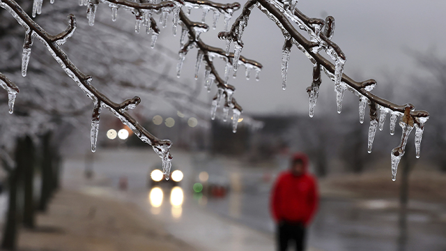
This sudden shift in temperatures could cause icy roads, especially Saturday night into early Sunday. If you need to be out, use extreme caution while driving.

Sunday: A Winter Reality Check
By Sunday, the storm moves out, but cold temperatures will settle in, making it feel like winter again.
- Indianapolis: Chilly and cloudy, high of 36°F (2°C), low of 23°F (-5°C).
- Fort Wayne: Cloudy and cold, high of 32°F (0°C), low of 19°F (-7°C).
- Evansville: Cooler with lingering clouds, high of 40°F (4°C), low of 28°F (-2°C).
- South Bend: Mostly cloudy and cold, high of 29°F (-2°C), low of 14°F (-10°C).
After near 60-degree warmth on Saturday, Sunday will feel brutally cold by comparison.
What You Need to Do to Stay Safe This Weekend
With dramatic temperature swings, potential flooding, and icy roads, here’s how you can stay safe and prepared:
- Stay updated on the forecast. Conditions could change quickly, so keep an eye on alerts from the National Weather Service and local meteorologists.
- Be cautious if traveling Saturday night into Sunday. Rain will freeze as temperatures drop, making roads dangerously slick. If you must drive, go slow and allow extra space between vehicles.
- Prepare for possible power outages. Strong storms and ice buildup could bring down power lines. Have flashlights, batteries, and backup heat sources ready.
- Dress for both warm and cold weather. You’ll want a light jacket in the morning, but a heavy coat by night. Layers are key!
- Watch out for flooding. Areas prone to high water could see flooding from heavy rainfall. Never drive through flooded roads—just a few inches of water can carry a car away.
What’s Next? Will This Be the Last Big Temperature Swing?
While next week looks calmer, temperatures will stay chilly, with highs mostly in the 30s and 40s. However, forecasters are watching another potential storm system later in the month that could bring more cold air and winter weather.
- Monday: Mostly cloudy, high of 38°F (3°C), low of 28°F (-2°C).
- Tuesday: A chance of rain and snow, high of 40°F (4°C), low of 30°F (-1°C).
- Wednesday & Thursday: Chilly but dry, with highs in the mid-40s, and lows near freezing.
Final Thoughts: Be Prepared for Anything This Weekend
Indiana’s weekend weather is the definition of unpredictable. Springlike warmth, heavy rain, thunderstorms, and an Arctic blast—all in just 48 hours. Stay informed, dress for the changing conditions, and be extra careful on the roads, especially Saturday night into Sunday. This wild ride isn’t over yet, so keep your winter gear handy and be ready for anything!