
Los Angeles is about to see a major shift in weather as a strong storm system moves in midweek, bringing heavy rain, cooler temperatures, and possible flooding in some areas. While the past few days have been clear and mild, residents should start preparing for potential disruptions on the roads and in flood-prone neighborhoods.
So, what’s happening?
A large storm system is expected to hit by Wednesday, bringing steady rain that could last through Friday. Forecasters say that some areas could see significant rainfall, raising concerns for flooding, rockslides in canyon areas, and dangerous driving conditions. If you have travel plans, outdoor events, or commutes to work, now is the time to get ready.
Current Conditions and What’s Coming Next
Right now, LA is enjoying clear skies and temperatures around 48°F (9°C) in the morning, warming up to around 70°F (21°C) by the afternoon. But don’t get used to the sunshine—it won’t last long.
Here’s what you can expect for the rest of the week:
- Monday, Feb 10: Some low clouds in the morning, then mostly sunny. High of 64°F (18°C), low of 47°F (8°C).
- Tuesday, Feb 11: Cooler, with morning clouds giving way to sunshine. High of 61°F (16°C), low of 46°F (8°C).
- Wednesday, Feb 12: The storm begins. Cloudy, with showers arriving in the afternoon. High near 57°F (14°C), low of 52°F (11°C).
- Thursday, Feb 13: Steady rain throughout the day. Some areas could see heavy downpours leading to flooding. High near 56°F (14°C), low of 53°F (12°C).
- Friday, Feb 14: A wet and cloudy morning, with showers tapering off in the afternoon. High of 63°F (17°C), low of 50°F (10°C).
- Saturday, Feb 15: The sun returns! Expect partly sunny skies with a high of 65°F (18°C), low of 51°F (11°C).

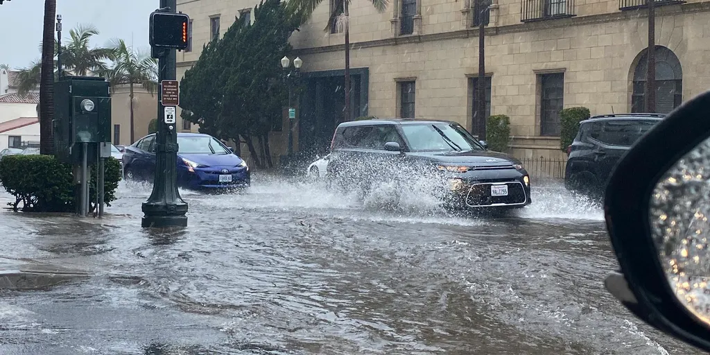
Biggest Weather Risks: Flooding and Road Hazards
The biggest concern with this storm is the potential for heavy rain over a short period, which could lead to street flooding, mudslides in hillside areas, and dangerous driving conditions. Residents near burn scar areas from past wildfires should be extra cautious, as these locations are more vulnerable to mudslides and debris flows when heavy rain hits. Drivers should also watch out for hydroplaning, especially during Wednesday and Thursday’s peak rain hours. If you can, avoid driving through flooded streets—even a few inches of water can cause your car to stall or be swept away.
How to Stay Safe and Prepared
- Check the Forecast Daily: The storm’s intensity could change, so keep an eye on the latest updates.
- Prepare for Heavy Rain: Clear out gutters and drains, and if you live in a flood-prone area, have sandbags ready.
- Drive with Caution: Roads will be slick, and visibility may be low. If possible, avoid driving during heavy rain.
- Stay Alert in Hillside Areas: If you live near canyons or wildfire burn scars, be on the lookout for possible mudslides or evacuation orders.
The Bottom Line
Los Angeles is about to shift from sunshine to storm mode, so don’t be caught unprepared. Expect cooler temperatures, steady rain, and possible flooding between Wednesday and Friday. By Saturday, the sun returns, but until then, plan, drive safely, and be ready for some wet weather!