
A major winter storm is sweeping through Ohio and Kentucky, with forecasts predicting up to 5 inches of snow by Wednesday morning. The National Weather Service (NWS) has issued Winter Storm Warnings across multiple counties, cautioning residents about dangerous road conditions, potential power outages, and travel disruptions.
Snowfall Predictions and Timing
The storm began moving into the area on Tuesday morning and will continue to intensify throughout the day. The heaviest snowfall is expected overnight, creating hazardous conditions during the Wednesday morning commute.
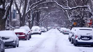
In central Kentucky, cities such as Lexington and surrounding regions can expect 3 to 5 inches of snow, while localized areas could see higher totals. In southern Ohio, particularly around Cincinnati, snowfall totals of 2 to 5 inches are forecast, with some areas experiencing a light glaze of ice on top of the snow.
Winter Storm Warnings and Affected Regions
The NWS Winter Storm Warning is in effect through 7 AM Wednesday for various counties in Kentucky and Ohio.
- Kentucky: Warnings are active for counties including Bracken, Grant, Mason, Owen, Pendleton, and Robertson.
- Ohio: Affected counties include Adams, Scioto, and neighbouring regions.
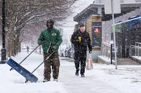
The combination of heavy snow and icy patches is expected to make travel extremely dangerous, and residents are advised to stay off the roads unless necessary.
Safety Tips and Travel Advisories
Authorities are urging residents to prepare for challenging travel conditions and follow these safety recommendations:
- Avoid unnecessary travel. If you must travel, ensure your vehicle is equipped with an emergency kit that includes food, water, blankets, and a flashlight.
- Allow extra travel time and drive slowly to avoid accidents on icy or snow-covered roads.
- Charge mobile devices and have backup power sources in case of power outages.
- Stay updated through local weather reports for changes in conditions or additional warnings.
State and Local Preparations
Local emergency services are working to pre-treat and clear roads, but snow accumulation rates of 1 to 2 inches per hour could make it difficult for road crews to keep up. Officials are also monitoring potential power outages due to the weight of snow and ice on power lines.
Some schools in the affected regions have announced potential closures or delays, with more decisions expected as the storm progresses.
What to Expect Next
The storm is expected to taper off by early Wednesday morning, but cold temperatures will persist, raising concerns about refreezing on roads and sidewalks. Meteorologists are also watching for additional winter storms later in the week, which could bring more snow or freezing rain to the region.
For now, residents are advised to stay home, stay safe, and stay informed as Ohio and Kentucky brace for a wintry 24 hours.