
Maryland residents should be prepared for a weekend of wild and unpredictable weather, as a powerful storm system will bring snow, heavy rain, and a dramatic drop in temperatures. Conditions will change rapidly, creating dangerous road conditions, the risk of flooding, and bitter cold that could lead to frostbite for those not properly prepared. If you have weekend plans, expect disruptions and plan.
Friday, February 14 – A Calm Start Before the Storm Hits
Friday will begin with mostly sunny skies and temperatures reaching a high of 41°F (5°C). While the day may feel relatively mild, winds will pick up, making it feel colder than the actual temperature. Don’t be fooled by the calm conditions—this is just the quiet before the storm. By the evening, clouds will start to build, signaling the arrival of a major system set to impact the region throughout the weekend.
Saturday, February 15 – Snow Moves In, Travel Could Be Tricky
Saturday will bring overcast skies and the arrival of snow in the morning and early afternoon. The snowfall isn’t expected to be heavy, but a light accumulation of 1 to 3 cm is possible, making roads slick and potentially hazardous. The high for the day will reach 38°F (3°C), but as temperatures hover just above freezing, the snow will gradually transition to rain. By evening, temperatures will hold steady at 36°F (2°C), and the ground will be cold and wet, setting the stage for even more dangerous conditions on Sunday. Anyone planning to be on the road should drive carefully and watch for icy patches, especially on bridges and overpasses, which freeze first.

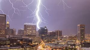
Sunday, February 16 – Heavy Rain, Possible Flooding, and Dangerous Winds
Sunday will bring the biggest weather shift of the weekend, as warmer air surges in and snow gives way to heavy rain. Temperatures will spike to 58°F (15°C), making it feel much warmer than previous days. But with this warmth comes steady, heavy rainfall, which could cause ponding on roadways and potential flooding in low-lying areas. Some areas may even experience thunderstorms, adding to the chaos. Winds will also increase, making conditions even more challenging for those traveling. If you live in a flood-prone area, stay alert for any warnings and be ready to move to higher ground if needed.
Monday, February 17 – A Brutal Arctic Chill Arrives
After Sunday’s rain and mild temperatures, a dramatic shift will take place overnight. By Monday morning, temperatures will plummet. The high will struggle to reach 38°F (3°C), and by nighttime, the temperature will drop to a frigid 18°F (-8°C). The sudden freeze means that any lingering water from Sunday’s rain could turn into dangerous black ice, creating hazardous conditions for the Monday morning commute. Wind chills will make it feel even colder, increasing the risk of frostbite for those exposed to the cold for too long.
How to Stay Safe During This Wild Weekend Weather
- Avoid Unnecessary Travel: Snow, heavy rain, and freezing temperatures will make roads dangerous all weekend. If you must drive, slow down and use extreme caution.
- Watch for Flooding: With steady rainfall on Sunday, streets and low-lying areas could flood quickly. Never attempt to drive through standing water—it’s impossible to tell how deep it is.
- Prepare for Black Ice: Any leftover moisture will freeze as temperatures drop sharply Sunday night, leading to slick and invisible ice patches Monday morning.
- Dress for the Cold: The sudden temperature plunge could put anyone outside at risk for frostbite. Wear layers, gloves, and a hat to stay warm.
Maryland, this is not just another winter weekend—conditions will change rapidly, and staying informed is critical. Keep a close eye on the forecast, be prepared for delays, and take all necessary precautions to stay safe!