
Louisiana is bracing for a weekend of intense weather, as forecasters warn of severe thunderstorms, damaging winds, and flash flooding across the state. The National Weather Service (NWS) has issued alerts urging residents to prepare for strong storms Saturday night into Sunday, with the potential for tornadoes and dangerous flash floods. This weather system could disrupt weekend plans, including Mardi Gras festivities, as heavy rainfall and damaging wind gusts of up to 60 mph swept through. Officials are urging caution, warning that flash flooding could make travel hazardous, while power outages and structural damage are possible due to high winds.
Saturday: Severe Storms and Heavy Rain Move In
The first wave of storms is expected to arrive Saturday evening, bringing heavy rainfall, thunderstorms, and strong winds. The most intense weather will likely occur overnight, making it especially dangerous as flooding could happen while many residents are sleeping.
- New Orleans: Expect thunderstorms and heavy rain, with strong wind gusts and possible flash flooding in low-lying areas. Highs will be 81°F (27°C), with temperatures dropping to 60°F (15°C) overnight.
- Baton Rouge: Severe weather likely, including high winds and isolated tornadoes possible. Highs will reach 83°F (28°C), with lows falling to 52°F (11°C).
- Shreveport: Morning showers will transition into severe storms by the afternoon, bringing flooding rains and damaging winds. Highs will be 73°F (23°C), lows dipping to 35°F (2°C).
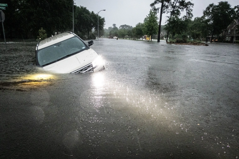
With already saturated grounds from previous rains, an additional 1 to 3 inches of rain could trigger flash flooding. Cities with poor drainage systems or near rivers and bayous will be especially vulnerable.

Sunday: Cooler Temperatures, But Flood Threat Remains
By Sunday morning, the storm will begin moving east, but floodwaters could still be rising in some areas. Rivers and streams may continue to rise for several hours after the rain ends, keeping flood threats high. Meanwhile, a strong cold front will bring sharply cooler temperatures, forcing Louisiana into a much colder and drier pattern.
- New Orleans: Highs will drop to 64°F (18°C) with strong winds making it feel colder.
- Baton Rouge: Breezy and cool, with highs reaching 60°F (15°C) and lows dipping to 35°F (2°C).
- Shreveport: Chilly and sunny, with temperatures peaking at 51°F (11°C) before plunging to 30°F (-1°C) overnight.
Drivers should use extreme caution on roads, as standing water combined with dropping temperatures could create slick or icy spots in northern Louisiana.
How to Stay Safe During This Dangerous Weather
With the risk of severe storms, flooding, and strong winds, it’s crucial to prepare now:
- Avoid Flooded Roads – Just six inches of moving water can knock a person down, and one foot of water can sweep away a car. Turn around, don’t drown!
- Secure Outdoor Items – Strong winds could turn patio furniture, decorations, and Mardi Gras parade floats into flying debris. Tie them down or bring them indoors.
- Prepare for Power Outages – High winds and flooding could knock out power, so charge your phones, gather flashlights, and have backup batteries ready.
- Have an Emergency Plan – If a flash flood warning or tornado warning is issued, know where to go for safety and have an emergency kit ready.
- Check on Elderly Neighbors and Pets – The sudden drop in temperatures could be dangerous for vulnerable individuals and animals left outside.
Stay Alert and Take This Storm Seriously
This isn’t just a routine storm—it has the potential to bring widespread flooding, dangerous winds, and power outages across Louisiana. Officials urge residents to take precautions, stay indoors if possible, and be ready for emergencies. Stay safe, stay informed, and don’t take any risks with this dangerous weather event.