
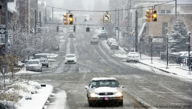
Michigan is about to get slammed by a powerful winter storm that will bring up to 12 inches of snow, dangerously cold temperatures, and hazardous travel conditions across the state. The National Weather Service (NWS) has issued Winter Storm Warnings and Advisories, warning residents to prepare for difficult travel and bitterly cold conditions lasting through the weekend. The storm will start late Friday night, intensify throughout Saturday, and linger into Sunday, making roads treacherous and visibility near zero in some areas. Once the snow moves out, an Arctic blast will sweep in, sending temperatures crashing well below freezing.
Friday Night: Snow Arrives, Roads Become Slick
The first bands of snow will begin late Friday night, covering the state in a fresh layer of snow by Saturday morning.
- Detroit: Light snow developing overnight with 1-3 inches by morning. High of 35°F (2°C), low of 27°F (-3°C).
- Grand Rapids: Snow starts late with accumulations up to 3 inches by sunrise. High of 31°F (-1°C), low of 25°F (-4°C).
- Lansing: Increasing clouds with snow after midnight, 2-4 inches expected by morning. High near 32°F (0°C), low of 24°F (-4°C).
Forecasters urge caution for anyone traveling overnight or early Saturday morning, as roads could quickly become snow-covered and slippery.

Saturday: The Worst of the Storm Hits
By Saturday morning, snowfall will intensify, with some areas seeing snow rates of 1-2 inches per hour.
- Detroit: 5-8 inches of snow expected, gusty winds could cause blowing snow and whiteout conditions. High of 31°F (-1°C), low of 15°F (-9°C).
- Grand Rapids: 8-12 inches possible, strong winds creating dangerous drifting. High of 29°F (-2°C), low of 13°F (-10°C).
- Lansing: Snow continues throughout the day, accumulating 6-10 inches before tapering off late. High near 28°F (-2°C), low of 13°F (-11°C).
Snowfall totals could surpass one foot in western Michigan, where lake-effect snow could enhance accumulation rates. Authorities warn against unnecessary travel as roads will become impassable in some areas. Blowing snow and whiteout conditions could make driving extremely dangerous, and any stranded vehicles could face dangerously cold wind chills.
Sunday: Arctic Blast Brings Life-Threatening Cold
As the snow moves out, a powerful Arctic front will push in, sending temperatures plummeting across the state.
- Detroit: Frigid and windy, highs in the teens with wind chills below zero. High of 19°F (-7°C), low of 2°F (-16°C).
- Grand Rapids: Wind chills as low as -15°F, dangerously cold for anyone outdoors. High of 17°F (-8°C), low of 3°F (-16°C).
- Lansing: Brutal cold, wind gusts up to 30 mph making it feel much colder. High near 15°F (-10°C), low of 2°F (-17°C).
Wind chills as low as -20°F could lead to frostbite in less than 10 minutes, making it dangerous to be outside for long periods.
How to Stay Safe During This Dangerous Winter Storm
With heavy snow, blizzard-like conditions, and extreme cold, it’s crucial to take safety measures:
- Avoid Traveling Unless Necessary – Roads will be hazardous, snow-covered, and nearly impassable in some areas. If you must drive, carry an emergency kit with blankets, food, and water.
- Prepare for Power Outages – Heavy snow could bring down power lines. Charge your devices, stock up on flashlights, extra batteries, and blankets.
- Bundle Up to Prevent Frostbite – With wind chills below -20°F, exposed skin can freeze in minutes. Wear multiple layers, gloves, and cover your face if heading outside.
- Check on Elderly Neighbors and Pets – Make sure they have heat and essential supplies. Bring pets inside, as the extreme cold could be deadly for animals left outdoors.
This Storm Could Be One of the Worst of the Season
This isn’t just another winter storm—it’s a serious and potentially life-threatening event. Blinding snow, dangerous wind chills, and icy roads could make travel nearly impossible. Stay home, stay warm, and stay informed. This storm could turn deadly for those caught unprepared—don’t take any risks!