
Residents across Utah are being urged to brace for a weekend of extreme winter weather, including heavy snowfall, significant avalanche risks, and treacherous travel conditions. The National Weather Service (NWS) has issued multiple advisories highlighting the dangers associated with this potent storm system expected from Saturday, February 15, through Monday, February 17.
Saturday: Heavy Snowfall and Avalanche Warnings
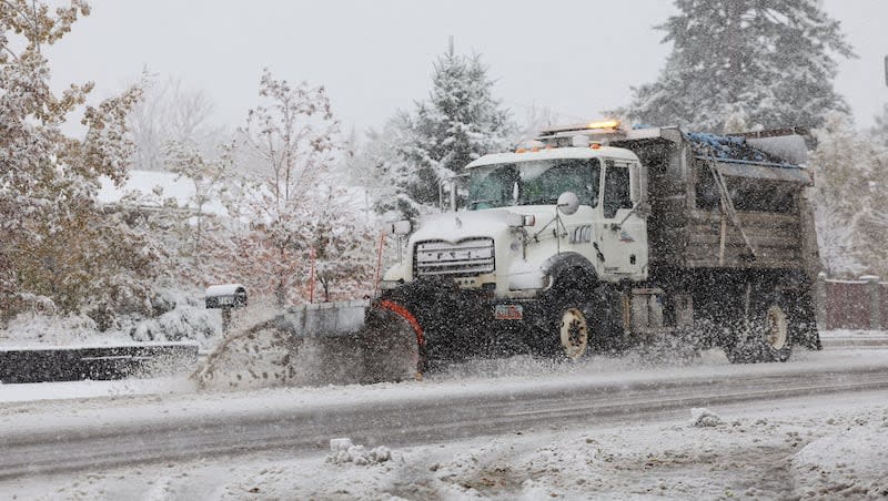
The weekend begins with a robust storm system delivering substantial snowfall across the state, particularly affecting mountainous regions. The NWS has issued a Winter Storm Warning in effect until 5:00 PM MST Saturday, with expectations of additional snow accumulations between 6 and 12 inches, and locally up to 2 feet in areas like the upper Cottonwoods, Bear River Range, and high Uintas. Winds could gust as high as 45 mph, leading to blowing and drifting snow.
Concurrently, the Forest Service Utah Avalanche Center has issued a Backcountry Avalanche Warning in effect from 6:00 AM MST Saturday to 6:00 AM MST Sunday. The avalanche danger is rated as HIGH and could escalate to EXTREME in some areas. Heavy snow combined with strong winds has created widespread areas of unstable snow, making natural and human-triggered avalanches certain. Residents are strongly advised to avoid travel in all avalanche terrain and steer clear of avalanche runouts.
-
Salt Lake City: Cloudy and breezy with a morning snow shower, then intervals of clouds and sun in the afternoon. High around 41°F (5°C), low near 31°F (-1°C).
-
Provo: Colder with a mix of sun and clouds. High approximately 39°F (4°C), low about 21°F (-6°C).
-
Ogden: A morning snow shower followed by mostly cloudy and colder conditions. High near 33°F (0°C), low around 30°F (-1°C).
Travelers should exercise extreme caution, as winter driving conditions are expected, and some roads may become impassable due to heavy snowfall and drifting.

Sunday: Continued Snowfall and Persistent Hazards
As the storm system progresses, snowfall is expected to continue, particularly in higher elevations, maintaining the risk of avalanches and hazardous travel conditions.
-
Salt Lake City: Cloudy and breezy in the morning, then a mix of sun and clouds in the afternoon with isolated showers possible. High around 46°F (8°C), low near 34°F (1°C).
-
Provo: Periods of clouds and sunshine. High approximately 42°F (6°C), low about 31°F (-1°C).
-
Ogden: Cloudy with 2-4 cm of snow in the morning, followed by brief showers in the afternoon. High near 41°F (5°C), low around 35°F (2°C).
Residents and visitors should remain vigilant, as conditions can change rapidly, and previously safe areas may become hazardous.
Monday: Gradual Improvement but Lingering Risks
By Monday, the storm is expected to weaken, but residual effects such as icy roads and lingering avalanche dangers may persist.
-
Salt Lake City: Partly sunny with a couple of showers. High around 44°F (7°C), low near 32°F (0°C).
-
Provo: Increasing sunshine throughout the day. High approximately 43°F (6°C), low about 28°F (-2°C).
-
Ogden: Some sun, then turning cloudy with a shower. High near 43°F (6°C), low around 34°F (1°C).
While major snowfall may subside, caution is still advised due to potential icy patches on roads and the possibility of delayed avalanches in certain areas.
Safety Precautions
Given the anticipated severe weather, residents and visitors are encouraged to take the following precautions:
-
Avoid Avalanche-Prone Areas: Refrain from traveling on or beneath slopes steeper than 30 degrees. Consult the Utah Avalanche Center for detailed information.
-
Limit Travel: Postpone non-essential travel, especially in mountainous regions. If travel is necessary, carry an emergency kit and inform others of your itinerary.
-
Stay Informed: Regularly monitor local weather forecasts and heed advisories or warnings issued by authorities.
-
Prepare for Power Outages: Heavy snow and strong winds may lead to downed power lines. Ensure you have alternative heating sources and sufficient supplies.
-
Check on Vulnerable Individuals: Ensure that elderly neighbors, those with health conditions, and pets are safe and have access to necessary resources.
This weekend’s weather in Utah presents a complex mix of hazards, including heavy snowfall, significant avalanche risks, and hazardous travel conditions. By staying informed and taking proactive measures, residents and visitors can navigate these challenges safely. Authorities will continue to monitor the situation and provide updates as conditions evolve.