
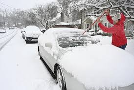
HARRISBURG, PA – A severe blizzard is gripping Pennsylvania, Maryland, and West Virginia, bringing dangerous whiteout conditions, heavy snowfall, and widespread power outages through Monday afternoon. The National Weather Service (NWS) has warned residents to stay indoors and avoid all non-essential travel, as visibility on the roads is near zero in some areas.
Storm Forecast and Expected Snowfall Totals
🌨 Start Time: Snowfall began late Sunday night and will continue through Monday afternoon.
🌨 Peak Intensity: Heavy snowfall rates of 1-2 inches per hour will cause rapid accumulation.
🌨 Wind Gusts: Fierce winds of 30-50 mph are creating blizzard conditions, making travel extremely dangerous.
🌨 Expected Snow Totals:
📍 Pittsburgh, PA: 10-14 inches
📍 Hagerstown, MD: 8-12 inches
📍 Morgantown, WV: 12-18 inches
📍 Baltimore, MD: 6-10 inches
Some higher elevations in the Allegheny Mountains could see up to 20 inches of snow.
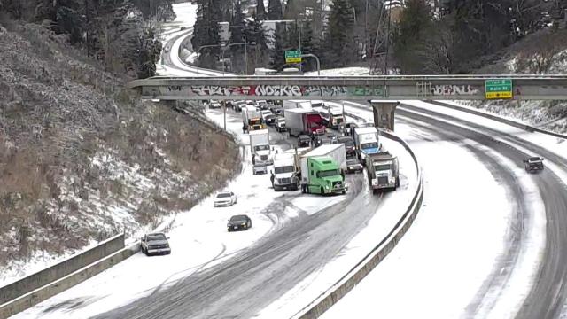
Travel Conditions: Roads Shut Down as Visibility Drops to Zero
🚧 Major Highways Impacted: The Pennsylvania Turnpike, I-70, I-81, and I-79 are covered in snow and ice, making travel treacherous. Authorities are considering temporary closures of heavily affected roadways.
🚧 Whiteout Conditions: Blowing and drifting snow will cause zero visibility in some locations.
🚧 Airport Disruptions: Hundreds of flights have been delayed or cancelled at major airports, including Pittsburgh International Airport (PIT) and Baltimore/Washington International (BWI).
State officials are urging people to stay off the roads, as emergency services may not be able to reach stranded drivers in some areas.
Power Outages & Safety Concerns
💡 Thousands Without Power: Heavy, wet snow and strong winds have already knocked out electricity for thousands of residents. Power companies are working on restorations, but outages may last for days in some areas.
🔥 Extreme Cold: With wind chills dropping to single digits, residents should take precautions to avoid hypothermia and frostbite.
🏠 Emergency Shelters Opening: Some cities are opening warming centres for residents without heat.
Closures & Cancellations
❄ Schools and government offices across the region are closed for Monday, with many shifting to remote learning and work-from-home policies.
❄ Public transit services in some cities have been temporarily suspended due to unsafe road conditions.
How to Stay Safe During the Blizzard
✔ Stay Indoors: Do not go outside unless necessary.
✔ Prepare for Power Outages: Charge devices, have extra batteries, and stock up on food and water.
✔ Avoid Travel: If you must drive, keep emergency supplies in your vehicle, including blankets, a flashlight, and extra food.
✔ Check on Neighbors: Elderly or vulnerable individuals may need assistance during extended outages.
✔ Stay Updated: Follow National Weather Service alerts and local news for emergency updates.
What to Expect Next
The storm is expected to weaken by Monday evening, but lingering snow showers and gusty winds will continue into Tuesday morning. Cleanup efforts will be delayed due to high snow totals, and travel may remain difficult for the next 24-48 hours.
For real-time updates, visit the National Weather Service website, tune into local emergency broadcasts, and check with utility companies for power outage restoration updates.
Stay safe and be prepared as this dangerous blizzard continues to impact the region!