
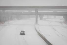
A Winter Storm Watch has been issued for parts of Virginia and North Carolina, with up to 5 inches of snow expected by Wednesday. Forecasters warn that hazardous travel conditions and school or business closures may result as snowfall accumulates across the region.
Storm Forecast and Timeline
Meteorologists predict that the system will move in from the west on Tuesday night, bringing light snow and a wintry mix before intensifying Wednesday morning. The heaviest snowfall is expected during the morning and afternoon hours on Wednesday, potentially disrupting commutes and daily activities.
- Snow Accumulation: Most areas will see 2 to 5 inches, with higher elevations possibly exceeding those totals.
- Temperatures: Expect temperatures to stay in the 20s and low 30s, making road conditions icy.
- Wind Gusts: Breezy conditions with gusts up to 25 mph could lead to blowing snow and reduced visibility.
Areas Most Affected
Richmond, VA: 2 to 4 inches of snow, with slick roads expected
Roanoke, VA: 3 to 5 inches, with localized heavier amounts possible
Greensboro, NC: 1 to 3 inches, with a mix of snow and ice creating hazardous travel
Raleigh, NC: 2 to 4 inches, with some areas experiencing freezing rain before the snowfall
Travel and Safety Concerns
- Dangerous Road Conditions: Snow and ice accumulation could make major highways, including I-95, I-85, and I-81, dangerous for travel during the morning and evening commutes.
- Flight Disruptions: Expect flight delays and possible cancellations at Richmond International Airport (RIC) and Raleigh-Durham International Airport (RDU).
- Power Outages Possible: With ice buildup on trees and power lines, isolated outages may occur in parts of Virginia and North Carolina.
How to Prepare for the Winter Storm
✔ Plan Ahead for Travel Delays: If possible, avoid non-essential travel on Wednesday morning and afternoon.
✔ Prepare for Power Outages: Charge devices, stock up on flashlights, and keep blankets and emergency supplies handy.
✔ Dress for the Cold: Temperatures will remain below freezing, so wear layered clothing, gloves, and hats if heading outdoors.
✔ Watch for School and Business Closures: Check for early dismissals or remote work/school announcements in your area.
✔ Stay Informed: Keep an eye on weather updates from the National Weather Service and local authorities.
What’s Next?
This winter storm is expected to move out by Wednesday night, but cold temperatures may keep roads slick and icy through Thursday morning. Warmer conditions should return by the weekend, but another winter system could impact the region next week.
For the latest storm updates, visit the National Weather Service website or tune into local news channels. Residents are urged to prepare now and take precautions as the storm approaches.