
A Winter Storm Warning has been issued for large portions of North Carolina, as freezing rain and icy conditions are expected to impact the region from Wednesday into Thursday. Forecasters warn that the combination of cold temperatures, ice accumulation, and gusty winds could lead to dangerous travel conditions, power outages, and widespread disruptions.
Timing and Expected Conditions
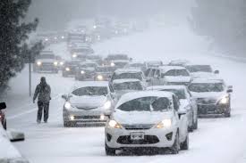
The winter storm is expected to arrive early Wednesday morning, bringing light rain before transitioning to freezing rain and sleet as temperatures drop below freezing. The most intense impacts will occur Wednesday night into early Thursday morning, with roads, bridges, and overpasses becoming slick and hazardous.
- Start Time: Early Wednesday morning
- Peak Impact: Wednesday evening through early Thursday
- End Time: Conditions will improve by late Thursday afternoon
Forecasters predict up to a quarter-inch of ice accumulation in parts of central and western North Carolina, increasing the risk of travel hazards and downed power lines.
Regions Most at Risk
- Raleigh-Durham: Freezing rain expected overnight, leading to icy roads and dangerous driving conditions
- Charlotte: A mix of sleet and freezing rain could make travel extremely hazardous
- Greensboro & Winston-Salem: Higher risk of significant ice buildup, increasing the chance of power outages
- Asheville & Western North Carolina: Mixed precipitation expected, with road conditions deteriorating quickly
Major Travel and Safety Concerns
State officials warn that roads will become treacherous, with black ice forming overnight as temperatures remain below freezing.
- Highway Safety: Interstates I-85, I-40, and I-77 will likely be covered in ice, leading to dangerous travel conditions
- Bridges & Overpasses: These areas will freeze first, increasing the risk of accidents
- Airport Disruptions: Flight delays and cancellations are expected at Charlotte Douglas International Airport and Raleigh-Durham International Airport
- Power Outages: Ice buildup on power lines and tree branches may lead to widespread electrical outages, particularly in central and western North Carolina
How to Prepare for the Storm
- Limit Travel: If possible, stay off the roads, especially during the overnight hours when ice is most likely to form
- Stock Up on Essentials: Have enough food, water, and medications in case road conditions prevent travel
- Prepare for Power Outages: Charge electronic devices, have flashlights and extra batteries available, and keep blankets handy
- Protect Pipes from Freezing: Let faucets drip slightly to prevent pipes from bursting
- Check on Neighbors: Ensure elderly individuals and those with medical conditions have heat and supplies
When Will Conditions Improve?
The worst of the storm will subside by Thursday afternoon, but lingering ice could keep roads dangerous into Friday morning. Rising temperatures by the weekend should help melt any remaining ice, but commuters should expect delays and continued slick conditions through the latter half of the week.
Local officials urge residents to prepare now for dangerous winter weather and monitor National Weather Service updates for the latest advisories. Authorities emphasize that freezing rain and ice storms are among the most hazardous winter weather events, and those in affected areas should take precautions immediately.