
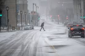
A dangerous Arctic blast is gripping eastern Iowa, with the National Weather Service (NWS) issuing an Extreme Cold Warning for Cedar Rapids, Dubuque, and Iowa City through Tuesday at noon. Forecasters warn that wind chills could drop as low as -30°F, creating life-threatening conditions for those exposed to the cold.
The extreme cold, combined with gusty winds up to 25 mph, will make outdoor conditions hazardous. Frostbite can develop in less than 10 minutes, and hypothermia is a serious risk for anyone without proper winter gear.
How Cold Will It Get?
- Air Temperatures: Lows between -5°F and -15°F overnight
- Wind Chills: Feels-like temperatures of -25°F to -35°F
- Winds: Gusts up to 25 mph, creating dangerously low wind chills
Areas Most Affected
Cedar Rapids: Wind chills of -30°F, making it dangerous to be outside for extended periods
Dubuque: Feels-like temperatures near -35°F, frostbite risk in 5 to 10 minutes
Iowa City: Wind chills as low as -25°F, making travel and outdoor exposure hazardous
Major Concerns & Safety Risks
Frostbite & Hypothermia Risk: Skin can freeze in less than 10 minutes in these conditions
Icy Roads & Black Ice: Freezing temperatures could make highways and sidewalks dangerously slick
Power Grid Strain: Increased heating use may cause localized outages
Frozen Pipes Risk: Prolonged subzero temperatures can burst water pipes, causing costly damage
How to Stay Safe During the Extreme Cold
✔ Stay Indoors Whenever Possible: Avoid unnecessary travel and exposure to frigid temperatures
✔ Bundle Up If You Must Go Outside: Wear multiple layers, hats, gloves, and insulated boots
✔ Protect Your Pipes: Leave faucets dripping and insulate exposed pipes to prevent freezing
✔ Check on Elderly and Vulnerable Individuals: Ensure neighbours have heat and necessary supplies
✔ Keep Pets Indoors: Animals should not be left outside in these dangerously cold conditions
When Will Conditions Improve?
Temperatures will gradually rise above zero by Tuesday afternoon, but wind chills will remain dangerously low through midweek. A brief warm-up is expected later in the week, but another Arctic front could return by the weekend, keeping much of Iowa locked in a deep freeze.
Officials urge residents to take precautions now, as this level of extreme cold can be life-threatening. Stay tuned for updates from the National Weather Service and local emergency management teams.