
A powerful lake effect snowstorm is set to impact Niagara County, New York, with up to 8 inches of snowfall expected by 1 PM Wednesday. The National Weather Service (NWS) in Buffalo has issued a Winter Weather Advisory, warning residents of hazardous travel conditions and reduced visibility.
Snowfall and Wind Conditions
Forecasters predict that northern parts of Niagara County will be hardest hit, as cold air moving over Lake Ontario fuels intense snow bands. Some areas could see snowfall rates of up to an inch per hour, making roadways slick and difficult to navigate.
Along with the heavy snow, wind gusts up to 35 mph are expected, creating blowing and drifting snow. These conditions will reduce visibility significantly, especially in open areas and near the Lake Ontario shoreline. The snow is expected to continue through Wednesday afternoon, gradually tapering off later in the day.
Travel and Road Conditions
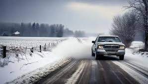
The combination of heavy snow and gusty winds will make travel hazardous, particularly during the morning and evening commutes on Tuesday and Wednesday. Officials are urging motorists to drive slowly, keep a safe distance from other vehicles, and allow extra time to reach their destinations.
The lake effect snow bands will be intense but highly localized, meaning some areas may see very little accumulation while others just a few miles away get buried under inches of snow. Drivers should be prepared for rapidly changing road conditions and avoid unnecessary travel when the snow is at its heaviest.
Safety Tips for Residents
- Drive Cautiously: If you must travel, keep emergency supplies in your car, including food, water, blankets, and a flashlight.
- Prepare for Power Outages: Strong winds and heavy snow could bring down tree branches and power lines, so have extra batteries and a backup heat source ready.
- Stay Updated: Follow local weather updates to track changing conditions and any new advisories.
- Check on Neighbors: Ensure elderly or vulnerable neighbours have heat, food, and any necessary supplies.
What’s Next?
After the snow tapers off on Wednesday afternoon, cold temperatures will linger, keeping roads icy and slick through the night. Residents should prepare for continued winter weather impacts and stay alert for any further advisories from the National Weather Service.
For the latest weather updates, tune in to local news stations or visit the National Weather Service’s website. Stay safe and take precautions as this winter storm moves through the region.