
North Carolina is facing a significant winter storm, with snow, ice, and freezing temperatures expected to create dangerous conditions through Thursday. The National Weather Service (NWS) has issued a Winter Weather Advisory, warning residents about hazardous roads, school closures, and possible power outages.
What to Expect
The advisory is in effect until early Thursday morning and includes much of central and eastern North Carolina. Areas near the Virginia border and northeastern parts of the state may see the most snowfall, with up to 6 inches possible. Other parts of the state, including the Triangle, Fayetteville, and the Triad regions, are expected to receive 1 to 2 inches of snow, along with sleet and freezing rain.
Forecasters warn that icy conditions could be the biggest concern, particularly in eastern North Carolina, where freezing rain may lead to ice buildup on trees and power lines. This raises the risk of power outages and hazardous travel conditions.
Schools and Transportation Impacted
Many school districts have announced closures or a switch to remote learning to keep students safe. Some of the affected districts include Wake County, Johnston County, Alamance-Burlington, Durham, Chapel Hill-Carrboro, Orange County, Winston-Salem, Forsyth, Harnett, and Nash County Schools.
Public transit is also being affected, with GoTriangle transit services suspending operations for Wednesday. Limited services may resume on Thursday, depending on road conditions.
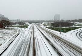
Travel Conditions & Road Safety
Officials are urging residents to stay off the roads if possible. The mix of snow, sleet, and freezing rain will make driving treacherous, especially on bridges, overpasses, and untreated roads. If travel is necessary, motorists should drive slowly, increase the following distance, and carry an emergency kit in their vehicle.
Authorities warn that temperatures will drop significantly overnight, meaning any moisture left on the roads could refreeze and create black ice conditions for Thursday morning’s commute.
How to Stay Safe
- Avoid Travel: If you must drive, go slowly and watch for icy patches, especially on bridges and shaded roads.
- Stay Warm: Dress in layers, hats, and gloves to protect against the bitter cold.
- Prepare for Power Outages: Ice accumulation on power lines could lead to outages. Have flashlights, blankets, and extra food ready.
- Check on Neighbors: Make sure elderly or vulnerable residents have the supplies they need to stay warm and safe.
- Stay Informed: Keep up with weather alerts and local news updates for real-time information on the storm’s impact.
Looking Ahead
As the storm moves out of the region by Thursday, temperatures are expected to remain below freezing, keeping roads slick and hazardous into the morning hours. Residents should continue exercising caution and staying indoors whenever possible.
For the latest updates, check with the National Weather Service, local news stations, and emergency management officials. Stay safe and take precautions as this winter storm grips North Carolina.