
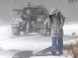
A powerful winter storm is moving into Washington and Oregon, bringing a dangerous mix of heavy snow, freezing rain, and strong winds. Forecasters warn that this storm could disrupt travel, cause power outages, and create hazardous road conditions through Thursday, February 20.
How Much Snow Will Fall?
The National Weather Service (NWS) has issued Winter Storm Warnings and Ice Storm Warnings across multiple regions, with up to 10 inches of snow possible in some areas.
- Washington: The Simcoe Highlands and the Eastern Washington Cascades could see some of the heaviest snow, with higher elevations expected to receive the full 10 inches. Lower-lying areas may see a mix of snow and ice, leading to dangerous road conditions.
- Oregon: The Blue Mountains, North Central Oregon, and the east slopes of the Cascades are in the storm’s path. Cities like Fossil, Maupin, La Pine, and Sisters should prepare for significant snowfall and ice accumulation.
Along with the snow, wind gusts of up to 45 mph are expected in some areas. These strong winds, combined with heavy snow and ice, will reduce visibility and increase the risk of fallen trees and power outages.
Travel Conditions Will Be Dangerous
This winter storm is expected to cause severe travel disruptions across both states.
- Highways and interstates could become treacherous, with snow-covered roads and black ice making driving extremely dangerous.
- The Oregon Department of Transportation (ODOT) and Washington State Department of Transportation (WSDOT) are already preparing road crews, but officials warn that conditions could deteriorate rapidly.
- Drivers are strongly advised to avoid unnecessary travel. If you must be on the road, slow down, increase your following distance, and have an emergency kit on hand.
Power Outages & Infrastructure Concerns
One of the biggest concerns with this storm is the potential for power outages. Ice accumulation on power lines and tree branches could lead to widespread service disruptions.
Residents are encouraged to:
- Charge all electronic devices ahead of time.
- Have backup power sources ready, such as battery packs or generators.
- Stock up on emergency supplies, including food, water, and blankets in case of prolonged outages.
How to Stay Safe
- Stay Off the Roads – If possible, avoid driving during the storm’s peak.
- Prepare for Power Outages – Have flashlights, extra batteries, and warm blankets on hand.
- Dress for the Cold – With wind chills expected to drop significantly, frostbite can occur quickly. Wear layers, gloves, and hats when going outside.
- Check on Neighbors – The elderly and those with medical conditions may need extra assistance.
- Stay Informed – Keep up with local news and weather alerts for real-time updates.
What’s Next?
The storm is expected to move out of the region by Thursday, but lingering cold temperatures and icy conditions could make travel difficult into the weekend. Road crews will be working to clear snow and ice, but residents should continue exercising caution.
For the latest updates, follow the National Weather Service, local news stations, and emergency management officials. Stay safe, stay warm, and prepare for this powerful winter storm as it moves across Washington and Oregon.