
If you live in Washington, Oregon, Idaho, Montana, or Northern California, brace yourself this storm is far from over. An atmospheric river, basically a firehose of moisture in the sky, is dumping relentless rain over the region, and it’s already creating chaos for millions.
Roads are underwater. Homes are being evacuated. Rivers are rising fast. And the worst part? The storm isn’t slowing down anytime soon.
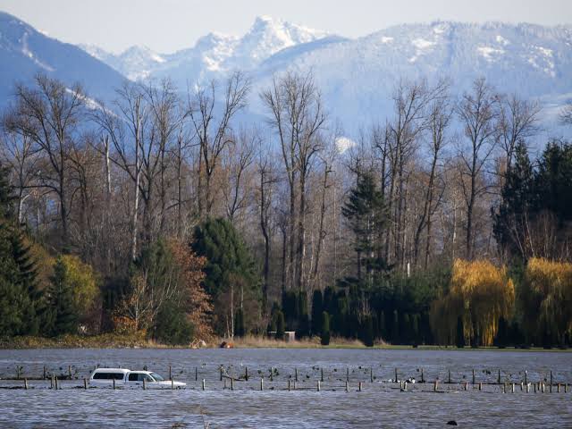
Washington and Oregon: A Wet Disaster Unfolding
For those in Washington and Oregon, it’s already looking like a disaster zone. Some areas have seen more rain in 24 hours than they typically get all month and there’s more on the way.
The biggest concern right now? Mudslides. Areas burned by wildfires in recent years are especially vulnerable, and officials are warning residents to be prepared to leave at a moment’s notice.
- We’re seeing water pouring off hillsides like waterfalls, said one emergency responder in Oregon. If you live near a slope, don’t wait for an evacuation order get out now.
- Idaho and Montana: Snowmelt is Making Flooding Even Worse
Further inland, Idaho and Montana are facing a double threat not just rain, but rapid snowmelt. The combination of warmer air and heavy rain is melting mountain snow at record speed, adding even more water to already swollen rivers.
This is a dangerous setup, said a meteorologist tracking the storm. We’re seeing rivers rise at an alarming rate, and some could crest at major flood stage within the next 24 hours.
If you live near a river or stream, be ready to move fast. Floodwaters can rise incredibly quickly, and once roads are submerged, rescue crews may not be able to reach you.
Northern California: A Ticking Time Bomb
For California, this storm is just the latest in a brutal stretch of extreme weather. The ground is already saturated from past storms, and now, with more heavy rain, the risk of mudslides and flash floods is skyrocketing.
If you live near a burn scar, don’t mess around, warned a state emergency official. Mudslides happen fast, and they don’t give second chances.
Why This Storm is So Dangerous
Atmospheric rivers aren’t just your average rainstorm. They carry more water than the Mississippi River except it’s all in the sky. When they hit land, that moisture comes crashing down as intense rainfall, sometimes dropping months worth of rain in just a few days.
This is exactly the type of storm that leads to billion-dollar disasters,said a climate expert. We’re talking about washed-out highways, entire towns isolated by floodwaters, and massive infrastructure damage.
How to Stay Safe as the Storm Rages On
If you’re in the affected area, don’t wait until it’s too late to prepare. Here’s what you need to do right now:
- Stay informed: Check your local weather updates and emergency alerts frequently.
- Have an evacuation plan: If you live in a flood-prone area, pack a go-bag and know your escape routes.
- Avoid flooded roads: It only takes a few inches of water to sweep a car away turn around, don’t drown!
- Watch for landslides: If you see trees tilting or hear a rumbling sound, get to safety immediately.
- Check on neighbors: Make sure elderly or vulnerable residents have what they need.
The Next 48 Hours are Critical
Weather experts say this storm could last through the weekend, meaning even more rain, more flooding, and worsening conditions. Emergency responders are urging people to be proactive, not reactive because once the floodwaters rise, help may not be able to reach you.
If you’re anywhere near a river, stream, or a recent wildfire burn scar, consider relocating now. It’s better to be safe than stranded.
This is not just another rainy day this is a major weather event that could turn deadly if you’re not prepared. Stay safe, stay dry, and don’t take this storm lightly.