
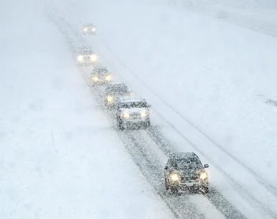
Idaho, get ready—a serious winter storm is heading our way, and it’s going to pack a punch. Forecasters say some areas could see up to 20 inches of snow by Monday morning, making travel dangerous and daily life a little tougher for the next few days.
What to Expect
- Heavy Snow, and Lots of It – Snow could pile up fast, making roads slick and difficult to drive on. Some areas will see a few inches fall every hour at times.
- Strong Winds – Expect gusts up to 35 mph, which will blow snow around and reduce visibility, making it feel even colder.
- Possible Freezing Rain – Later in the storm, some areas—especially between Burley and Pocatello—could see a mix of snow and freezing rain, which could make roads even more hazardous.
How to Prepare
- Stay Off the Roads If You Can – Conditions could get dangerous fast, especially with blowing snow and ice. If you have to drive, go slow, keep your gas tank full, and bring extra blankets and snacks in case you get stuck.
- Be Ready for Power Outages – Wet, heavy snow and strong winds could knock out power in some areas. Have flashlights, batteries, and a backup heat source if possible.
- Check On Family and Neighbors – This kind of weather can be tough on everyone, but especially on older adults and those who live alone. A quick phone call or knock on the door can make a big difference.
- Stay Updated – Storms like this can change quickly. Keep an eye on the latest weather reports so you’re not caught off guard.

Why Is This Storm So Intense?
This isn’t just another snowy day in Idaho. This storm is being fueled by an atmospheric river, a long stream of moisture from the Pacific that dumps huge amounts of snow when it hits the mountains. That’s why snowfall could be heavier and more unpredictable than usual.
This storm is going to be a big one, but a little preparation now can make it easier to get through. Stay warm, stay safe, and look out for each other.