
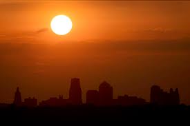
Kansas City, enjoy today’s warmth while you can, but be careful—strong winds and dry air have put us under a Red Flag Warning, meaning fire danger is high. And just when you think we’re in the clear, storms could roll in early next week, bringing heavy rain and possible severe weather.
What’s Coming Up
- Friday, February 28: A warm, sunny day with highs reaching 67°F (20°C). Sounds great, right? But strong winds and low humidity make today a fire hazard, so avoid outdoor burning and be mindful of anything that could spark flames.
- Saturday, March 1: Big temperature drop! Highs will only reach 47°F (8°C), so you’ll need a jacket again. Still mostly sunny, though.
- Sunday, March 2: A little warmer, with highs around 56°F (13°C). More clouds will roll in, but overall, it’ll be a nice day to get outside.
- Monday, March 3: Another pleasant day, with partly sunny skies and highs around 57°F (14°C). Enjoy it while it lasts!
- Tuesday, March 4: Heads up—storms are coming. Temperatures will climb to 65°F (18°C), but rain and thunderstorms could hit, possibly bringing flooding, hail, and strong winds. It’s too early to know exactly how bad it’ll be, but keep an eye on the forecast.
Why It Matters
Today’s fire risk is no joke—gusty winds and dry air mean fires could spread quickly. And while the weekend will be calmer, Tuesday’s storms could cause travel headaches and even severe weather. Make sure you’re prepared for quick weather changes, and stay weather-aware early next week.

Stay safe, Kansas City, and keep an eye on the skies!