
Brooklyn residents, get ready for a major shift in weather as a powerful storm system is set to move in midweek, bringing heavy rainfall, gusty winds, and potential flooding. The National Weather Service has issued a hazardous weather outlook, warning that this storm could bring serious disruptions to travel, power, and daily life. If you have plans for Wednesday or Thursday, you might want to prepare for delays, flooded streets, and windy conditions.
When Will the Storm Arrive?
The storm is expected to reach Brooklyn by Wednesday morning, bringing with it steady rain that will continue throughout the day and into Thursday. Wind gusts could reach up to 40 mph, particularly along the waterfront and exposed areas, adding to the potential damage.
One of the biggest concerns with this system is the combination of heavy rain and melting snow in areas north of the city, which could increase the risk of flooding. Rivers, drainage systems, and low-lying areas are especially vulnerable, meaning parts of Brooklyn, Queens, and lower Manhattan may see pooling water in streets, basements, and subway entrances.
By Friday, the storm will clear out, leaving cooler but drier weather behind. However, before the skies brighten up, Brooklynites should prepare for a rough 48 hours of stormy conditions.

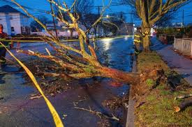
What Are the Biggest Dangers?
This storm has several serious risks that could impact daily life in Brooklyn:
- Flooding: Low-lying areas and streets with poor drainage could see significant water accumulation. Flash floods are possible in neighborhoods with older infrastructure.
- Strong Winds: Wind gusts of 40 mph or higher could lead to power outages, fallen branches, and flying debris. Coastal areas may experience even stronger gusts.
- Travel Disruptions: Roads and highways could become slick and flooded, making commuting dangerous. Public transportation delays are likely, especially for subway lines prone to flooding.
- Power Outages: With high winds, power lines could be impacted, leaving some neighborhoods without electricity for extended periods.
How to Stay Safe and Be Prepared
Since this storm is expected to hit during peak hours, taking action now can reduce risks and help you stay safe:
- Charge your phone and keep emergency alerts on so you receive updates.
- Secure any loose outdoor objects like trash cans, chairs, or decorations. Strong winds could turn them into flying hazards.
- Avoid flood-prone areas and do not drive through standing water. Even a few inches can stall a car or sweep a person off their feet.
- Prepare for power outages by having flashlights, batteries, and non-perishable food ready.
- If you live in a high-rise, stay away from windows during high winds.
Brooklyn is no stranger to extreme weather, but this midweek storm could bring serious disruptions if precautions aren’t taken. Stay alert, stay informed, and make sure you’re ready for what’s coming. By preparing now, Brooklynites can weather the storm safely and avoid unnecessary risks.