
San Diego, March 11, 2025 — If you thought San Diego was all sunshine and blue skies, this week’s forecast will have you reaching for your umbrella. A series of powerful storm systems is set to drench the region, bringing heavy rain, strong winds, and even snow in higher elevations. For a city that enjoys mild, dry weather most of the year, this kind of stormy setup is something residents need to prepare for.
Storm #1: A Wet and Windy Tuesday
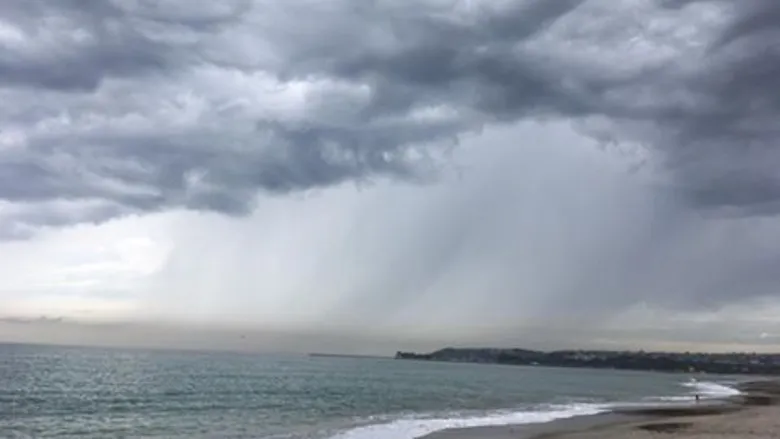
The first storm system arrives early Tuesday morning (March 11), bringing widespread rain throughout the day.
- Timing: Showers are expected to begin after 2 a.m., with the heaviest rain falling between 2 p.m. and 8 p.m.
- Rainfall Totals: Coastal and valley areas can expect 0.25 to 0.75 inches, while mountains may see up to an inch. Deserts will see less rain, likely under 0.20 inches.
- Potential Hazards: Isolated thunderstorms, brief heavy downpours, and small hail are possible. Roads will be slick, increasing the risk for accidents during the evening commute.
Storm #2: The Bigger Threat Arrives Wednesday-Thursday
Just as San Diego catches its breath from Tuesday’s rain, a stronger, more potent storm moves in from Wednesday afternoon (March 12) through Thursday evening (March 13).
- Timing: Rain starts late Wednesday and intensifies overnight into Thursday.
- Rainfall Totals: Coastal and valley areas could receive 0.75 to 1.50 inches, with mountains getting 1 to 3 inches. Deserts may see up to 0.50 inches.
- Flood Watch: A Flood Watch is in effect from 10 p.m. Wednesday through 6 p.m. Thursday, as rivers, creeks, and roadways could flood due to heavy rainfall.
- Snowfall: The San Bernardino and San Diego County mountains may get up to 6 inches of snow above 5,000 feet, making travel hazardous along mountain roads.
How to Stay Safe and Prepared
While these storms won’t bring hurricane-level impacts, they do pose risks. Here’s how you can stay safe:
- Avoid Flooded Areas – Do not attempt to drive through flooded streets. Turn around, don’t drown.
- Drive Cautiously – Wet roads mean longer braking distances and an increased risk of hydroplaning.
- Prepare for Power Outages – Strong winds could knock down trees and power lines. Keep flashlights, batteries, and a backup phone charger handy.
- Secure Outdoor Items – Patio furniture, trash bins, and decorations could become airborne in gusty winds.
- Mountain Travel Alert – If heading to the mountains, bring chains, extra blankets, and emergency supplies in case of road closures due to snow.
What’s Next?
After Thursday, drier and calmer weather is expected to return by the weekend. Temperatures will slowly climb back to normal, and San Diego’s iconic sunshine should return by Sunday.
For now, stay dry, stay informed, and be prepared for a rare week of wet and wild weather in SoCal!