
North Texas is in for a wild weather ride today. A strong cold front is sweeping through, bringing the potential for severe thunderstorms, large hail, and damaging winds. But that’s not the only concern—warm temperatures, gusty winds, and dry conditions are also increasing the wildfire risk across the region.
If you live in or around Dallas, you need to stay alert and prepare for fast-changing conditions. Here’s what you can expect and how to stay safe.
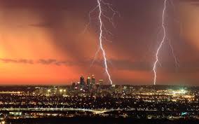
Severe Thunderstorms: Hail, Strong Winds, and Possible Tornadoes
A severe storm system is moving into North Texas this afternoon, with the highest risk between 3 PM and 7 PM. Here’s what’s on the radar:
- Large Hail: Some areas could see hail up to 2 inches in diameter—that’s roughly the size of eggs. If you park your car outside, consider moving it to a covered area.
- Damaging Winds: Gusts could reach 60 mph or more, which can knock down trees and power lines. Secure loose outdoor objects before the winds pick up.
- Tornado Risk: While tornadoes aren’t the main concern, a few isolated tornadoes can’t be ruled out. Stay weather-aware and have a safety plan in place.
Areas east of I-35, including Dallas, Sherman, and Denison, are at the highest risk for severe storms. If you hear thunder, head indoors—because if you can hear it, you’re close enough to be struck by lightning.
Wildfire Danger: Warm, Windy, and Dry Conditions Spell Trouble
As if severe storms weren’t enough, parts of North Texas are also facing an elevated wildfire risk.
Why?
- Unseasonably warm temperatures – Highs will reach the low 80s, well above the March average.
- Low humidity – Dry air sucks moisture out of vegetation, turning grass and brush into fire fuel.
- Strong winds – Gusts up to 40 mph could quickly spread any small spark into a fast-moving fire.
Areas south of I-20 and west of I-35, where drought conditions persist, are most at risk. If you live in these areas, avoid outdoor burning, and be extremely cautious with anything that could start a fire.
How to Stay Safe Today
With two major weather threats in play, here’s how to stay prepared:
- Charge your phone and devices – Power outages are possible.
- Park your car in a garage or under cover – Hail could cause serious damage.
- Bring in or tie down loose outdoor items – Trash bins, patio furniture, and decorations can become dangerous in high winds.
- Have an emergency plan – If a tornado warning is issued, know where to take shelter.
- Be extremely careful with fire – Avoid outdoor grilling or using machinery that could create sparks.
Final Thoughts
Dallas is facing a rare combination of severe storms and high wildfire risk in the same day. Stay informed, take precautions, and don’t take these warnings lightly. A little preparation now can keep you and your family safe.
Stay safe, Dallas—we’ll keep you updated as the situation unfolds.