
Oklahoma City is in for a week of dramatic weather changes, starting with hot, windy conditions and high fire danger before a strong cold front drops temperatures significantly midweek. With gusty winds and dry air, the risk of wildfires is extremely high early in the week, prompting warnings from the National Weather Service. If you’re enjoying the warm temperatures, take advantage of them early—by Wednesday, a 40-degree temperature drop will make it feel like winter is back.
Here’s what to expect for the week ahead:
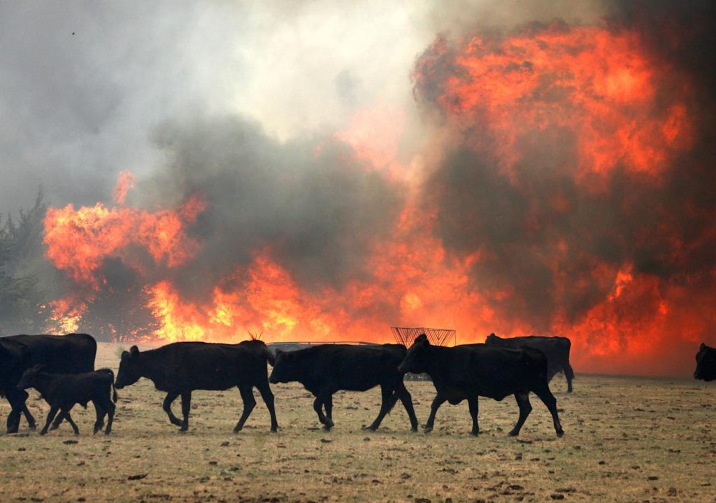
Monday, March 17: Hot, Windy, and High Fire Danger
- Highs will soar to 83°F (28°C), feeling more like late spring than March.
- South winds will be strong, 20-30 mph, with gusts up to 45 mph.
- The air will be extremely dry, increasing the risk of wildfires. A Red Flag Warning is in effect from 11 AM to 10 PM CDT.
- Outdoor burning is strongly discouraged, and any sparks or embers could ignite rapidly.
- The evening will be mild, with temperatures dropping to 57°F (14°C).
Tuesday, March 18: The Warmest Day of the Week
- Temperatures will climb to 86°F (30°C), making it the hottest day of the week.
- Winds will be even stronger, with gusts up to 50 mph, adding to the fire risk.
- A Fire Weather Watch is in effect, meaning conditions remain critical for wildfires.
- The night will bring cooler air as a strong cold front moves in, dropping temperatures to 44°F (6°C).

Wednesday, March 19: A Shocking Cool-Down
- Highs will struggle to reach 51°F (11°C), a sharp drop from Tuesday’s heat.
- Morning clouds will give way to sunshine, but it will feel noticeably colder.
- Winds will shift, bringing a much chillier breeze throughout the day.
- By evening, temperatures will fall to 35°F (2°C), making for a cold night.
Thursday, March 20: Slow Recovery from the Cold
- Temperatures will gradually warm back up, reaching 61°F (16°C).
- Skies will be hazy, with light winds making the day feel more comfortable.
- The night will still be chilly, with lows around 44°F (7°C).
Friday, March 21: A Milder End to the Week
- The warming trend continues, with highs reaching 68°F (20°C).
- Sunshine returns, making for a much more pleasant day.
- The night will be cool but comfortable, with temperatures around 50°F (10°C).
What You Need to Know:
- Fire Danger is Extremely High Early in the Week: Strong winds and dry air mean wildfires could spread quickly. Avoid burning anything outdoors, and be cautious with cigarettes, grills, and other potential ignition sources.
- Temperature Drop Wednesday: A 40-degree temperature difference between Tuesday and Wednesday will make it feel like two different seasons in one week. Dress in layers to stay comfortable.
- Winds Will Be Strong: Secure outdoor furniture, trash cans, and decorations to prevent them from blowing away.
- No Rain in Sight: Despite a few clouds, no significant rainfall is expected this week.
Looking Ahead
This week will feel like two different seasons, with summer-like heat early on and a winter chill midweek. Stay fire-aware, dress for changing temperatures, and prepare for gusty winds. By the weekend, things will start to feel more like spring again.