
Northern California is bracing for a powerful winter storm starting Wednesday night, bringing relentless rain, feet of snow in the mountains, and damaging winds through the end of the week. Whether you’re in the Sierra, the Bay Area, or the Central Valley, expect some wild weather that could make travel dangerous and even cause power outages.
Sierra Nevada: Feet of Snow and Whiteout Conditions
If you’re thinking about heading to the mountains, you might want to rethink those plans. Up to 4 feet of snow is expected in the Sierra, with intense snowfall rates of 2 inches per hour at times. Winds gusting over 60 mph will make conditions even worse, leading to potential road closures, whiteout conditions, and avalanche risks.
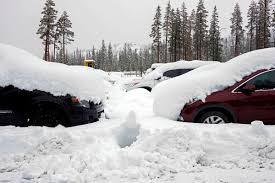
A Winter Storm Warning is already in effect, and officials are urging people to avoid mountain travel if possible. Major routes like I-80 and Highway 50 could be shut down due to heavy snow and poor visibility, so if you must travel, bring extra supplies and expect major delays.
Bay Area and Central Valley: Flooding Rains on the Way
Meanwhile, in lower elevations, it won’t be snow causing problems—it’ll be heavy rain and flooding. Some areas could see up to 5 inches of rain, especially in the foothills and coastal mountains. Cities like San Francisco, Oakland, and Sacramento are all in the storm’s path, meaning streets could flood and mudslides are possible in recent wildfire burn areas.
A Flood Watch is in place from Wednesday night through Friday. If you live in a flood-prone area, now is the time to clear drains, grab sandbags, and have an emergency plan ready.
Coastal Winds and Dangerous Surf
This storm is packing a punch, even along the coast. Gusty winds up to 60 mph could knock down trees and power lines, potentially leading to widespread power outages. Beachgoers should also stay cautious—waves could reach up to 30 feet, creating extremely dangerous surf conditions.
How to Prepare
- Avoid mountain travel if possible. Conditions will be treacherous.
- Charge your devices in case of power outages.
- Stay off flooded roads. Even a few inches of water can be dangerous.
- Secure outdoor furniture—high winds can turn loose items into flying hazards.
This storm is expected to weaken by Friday night, but another system could roll in by the weekend. Stay safe, stay dry, and keep an eye on updates.