
Chicagoans, get ready—this weekend’s weather will be a brutal mix of heavy snowfall, biting winds, and dangerous cold. If you haven’t prepared yet, now is the time, because conditions will deteriorate rapidly as the weekend progresses.
Friday, February 14 – The Storm Starts to Move In
Friday will begin cold but relatively calm, with some sunshine early in the day. However, don’t be fooled by the quiet start—the first signs of the storm will creep in by the afternoon. Clouds will thicken, and snow showers will begin developing later in the day. The high temperature will reach 28°F (-2°C), but with winds increasing, it will feel even colder. As the evening sets in, the light snow could accumulate quickly on roads and sidewalks, leading to slippery conditions for the evening commute.
Saturday, February 15 – Thick Clouds and Steady Snowfall
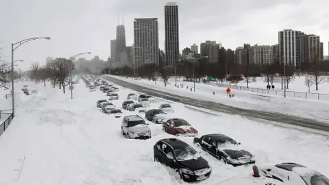
Saturday will bring heavier snowfall, though accumulations will vary across different parts of the city. Chicago is expected to receive an additional 3-6 cm of snow, with temperatures hovering around 33°F (1°C) during the day. The real problem won’t just be the snow itself—it’s the strong winds that will whip through the city, creating near-whiteout conditions in some areas. Wind gusts will make it difficult to see and drive, so anyone planning to be on the road should exercise extreme caution. By evening, temperatures will begin to drop sharply, setting the stage for an even more dangerous Sunday.

Sunday, February 16 – A Deep Freeze Takes Hold
Sunday’s forecast brings brutal Arctic air into the region. Chicago will struggle to reach a high of just 26°F (-3°C), and as the night sets in, temperatures will plummet to 0°F (-18°C). On top of the frigid temperatures, snow showers will continue, adding another 1-2 cm of accumulation. The real concern will be black ice, as freezing temperatures turn melted snow into an invisible hazard on roads and sidewalks. The bitter wind chills will make it feel far colder than the actual temperature, increasing the risk of frostbite in just minutes for anyone exposed to the cold.
Monday, February 17 – Dangerous Cold Hits Hard
By Monday, Chicago will be locked in some of the coldest air of the season. The high temperature will barely reach 9°F (-13°C), and overnight, it could drop to -1°F (-18°C). Wind chills will make it feel much colder, putting residents at serious risk for frostbite and hypothermia. Schools and businesses could be affected if road conditions remain hazardous, and those who must go outside should layer up and take every precaution.
How to Stay Safe During This Winter Blast
- Avoid Traveling if Possible: Snow, ice, and freezing winds will make roads extremely dangerous. If you must drive, slow down and stay alert.
- Watch for Black Ice: Freezing temperatures overnight will turn any remaining moisture into invisible ice patches on roads and sidewalks.
- Prepare for Power Outages: Strong winds and ice buildup could lead to downed power lines. Have flashlights, extra blankets, and emergency supplies ready in case of an outage.
- Dress for Extreme Cold: This kind of Arctic blast can be deadly if you’re not dressed properly. Wear layers, gloves, hats, and waterproof boots to protect yourself from frostbite.
Chicago, this storm is not one to take lightly—conditions will change rapidly, and a deep freeze could make roads and sidewalks hazardous for days. Stay informed, stay prepared, and take all necessary precautions to stay safe this weekend.