
Georgia is about to experience one of the most extreme weather swings of the season, with severe storms, flash flooding, and tornado threats hitting first—followed by a rapid temperature crash that could lead to icy roads and dangerous conditions. Meteorologists warn that this powerful storm system will move through Georgia over the weekend, bringing damaging winds, heavy rain, and possible tornadoes. By late Sunday, a massive Arctic cold front will cause temperatures to plummet by 30 degrees or more in just a few hours, setting up the risk of black ice and a brutally cold start to the week.
Saturday: Severe Storms and Tornado Threat
The National Weather Service (NWS) has placed much of Georgia under a Level 3 out of 5 risk for severe storms. These storms will begin developing Saturday evening and continue overnight into Sunday morning.
- Thunderstorms will intensify Saturday night, bringing damaging wind gusts up to 75 mph, which could knock down trees and power lines.
- Tornadoes are possible, particularly in central and southern Georgia, where conditions are ideal for rotating storms.
- Flooding rains will drench much of the state, with up to 3 inches of rain expected in some areas, overwhelming drainage systems.
Residents should have multiple ways to receive emergency alerts, especially since the most intense storms will occur overnight while many are sleeping.

Sunday: Storms Continue Before a Sudden Temperature Drop
Sunday morning will start mild and stormy, but by the afternoon, the severe weather will move out—and the cold air will come crashing in.
- Temperatures will start in the 60s and 70s°F early Sunday but will quickly drop into the 30s°F by evening.
- Strong winds behind the cold front will make it feel even colder, with wind chills dipping into the 20s°F by late Sunday night.
- Any remaining moisture on the roads could freeze, leading to dangerous black ice conditions for drivers Monday morning.
Monday: Cold and Icy Start to the Week
The storm will be gone, but the frigid air will remain, leaving Georgia much colder than it has been in weeks.
- Highs on Monday will struggle to get above 40°F, and overnight lows could drop into the 20s°F across much of the state.
- Any lingering wet roads will freeze overnight, making the morning commute treacherous in some areas.
- Wind chills will be even colder, making it feel like the teens in parts of northern Georgia.
How to Stay Safe Before, During, and After the Storm
- Stay Weather Aware: Follow local news and have NOAA weather radio or smartphone alerts turned on, especially for overnight tornado warnings.
- Prepare for Power Outages: With strong winds and potential tornadoes, be ready for possible widespread outages. Charge phones, gather flashlights, and have an emergency kit ready.
- Avoid Flooded Roads: Turn around, don’t drown! Even just six inches of moving water can sweep away a vehicle.
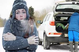
- Dress for the Cold: After the storms, temperatures will drop dangerously low. Make sure you have warm layers and limit time outside.
- Be Cautious of Black Ice: If you must drive Monday morning, assume roads are icy, especially on bridges and overpasses.
Georgia Must Prepare Now!
This weekend’s severe storms and sudden freeze pose a real danger to Georgia residents. Tornadoes, damaging winds, and flooding could hit Saturday night, then temperatures will nosedive, creating a serious risk of icy roads and power outages. Prepare now, stay updated, and take this storm system seriously—because the impacts could be life-threatening.