
Kentucky is bracing for torrential rains, widespread flooding, and dangerous storms this weekend, forcing Governor Andy Beshear to declare a state of emergency. Forecasters warn that up to 5 inches of rain could fall in some areas, overwhelming rivers and low-lying regions, while a surge of Arctic air will send temperatures plummeting immediately after the storm. The National Weather Service (NWS) has issued flash flood warnings and severe weather alerts across the state, urging residents to prepare for possible evacuations and power outages. Officials warn that some rivers could crest at their highest levels in years, making the risk of life-threatening floods even greater.
Saturday: Torrential Rain and Severe Storms Could Lead to Deadly Flooding
The heaviest rainfall is expected Saturday through early Sunday, with severe thunderstorms potentially adding damaging winds and isolated tornadoes into the mix.
- Louisville: Heavy rain throughout the day, with flooding in low-lying areas possible. High: 48°F (9°C), low: 32°F (0°C).
- Lexington: Strong thunderstorms and continuous rain, flooded roads likely. High: 53°F (12°C), low: 35°F (2°C).
- Bowling Green: Intense downpours, and thunderstorms bringing high winds. High: 64°F (18°C), low: 36°F (2°C).
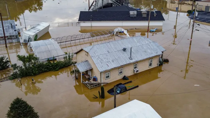
Emergency crews are preparing for swift water rescues as rivers are expected to rise dangerously fast. Residents living near creeks, streams, and flood-prone neighborhoods are urged to have an evacuation plan ready.

Sunday: Flash Flooding Lingers as Arctic Air Rushes In
Even after the rain slows down, floodwaters will continue to rise as runoff fills rivers and reservoirs. Major flooding is expected along the Kentucky River, Green River, and Ohio River, with some areas seeing water levels higher than anything recorded in the past decade.
Adding to the chaos, an Arctic cold front will sweep through Kentucky late Sunday, sending temperatures plummeting.
- Louisville: Breezy and turning sharply colder, with morning rain turning to snow flurries. High: 37°F (3°C), low: 18°F (-8°C).
- Lexington: Windy and colder, morning rain giving way to freezing temperatures. High: 44°F (7°C), low: 20°F (-7°C).
- Bowling Green: Cloudy with falling temperatures, wet roads could turn icy overnight. High: 39°F (4°C), low: 20°F (-7°C).
The sudden freeze could turn wet roads into sheets of ice, making travel treacherous early next week.
How to Stay Safe During This Weather Emergency
With rising waters and severe weather, officials are urging Kentuckians to take action now:
- Avoid Flooded Roads – NEVER drive through standing water! Even 6 inches of moving water can sweep away a car, and flooded roads may hide sinkholes or washed-out pavement.
- Prepare for Power Outages – High winds and flooding could bring down power lines, so charge phones, gather flashlights, and stock up on food and water.
- Stay Alert for Evacuation Orders – If your area is flood-prone, be ready to leave at a moment’s notice. Officials stress that waiting too long to evacuate could be deadly.
- Bundle Up for the Cold – After the storm, temperatures will drop sharply, bringing dangerous wind chills and the risk of icy conditions.
This Storm Could Be Deadly
This is not just another storm—this is a life-threatening weather event that could bring catastrophic flooding, power outages, and extreme cold in just a matter of hours. Officials are urging residents to stay off the roads, prepare for power failures, and follow evacuation orders if necessary. This storm is dangerous—stay informed and stay safe!