
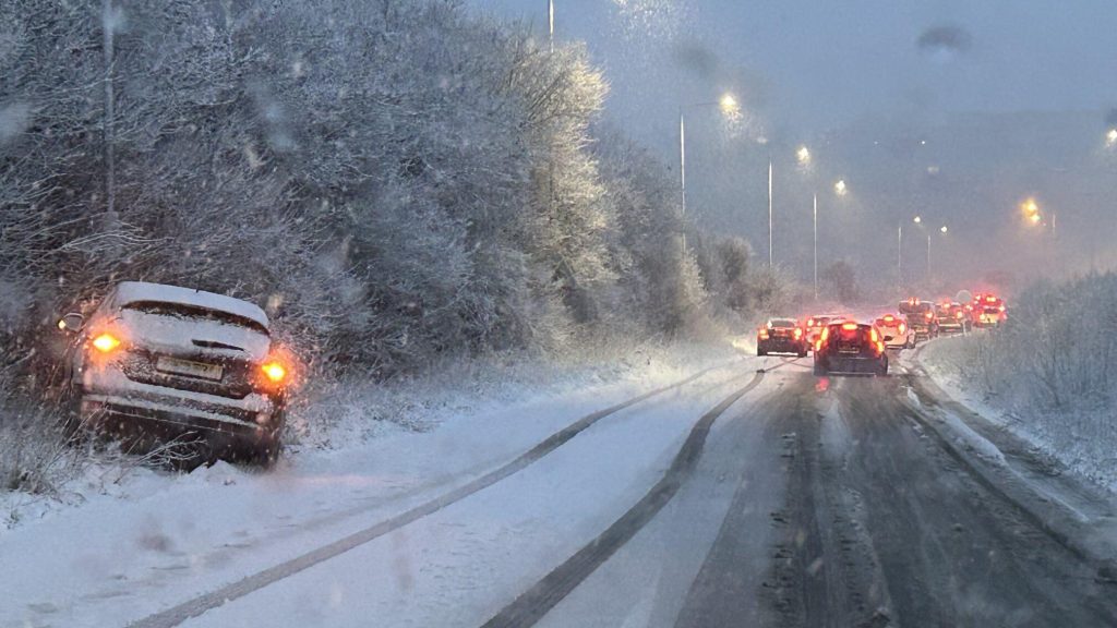
Residents of Sussex County should prepare for an intense winter storm set to bring dangerously low temperatures, heavy snowfall, and strong winds in the coming days. The National Weather Service has issued a Winter Storm Warning, cautioning against hazardous travel and extreme wind chills that could lead to frostbite in minutes.
How Cold Will It Get?
The deep freeze has already begun. As of Tuesday morning, temperatures in Sussex County have dropped to a bitter 16°F (-9°C). But with gusty winds reaching up to 55 mph, it feels even colder. Wind chills have already dipped below zero in some areas, and conditions will worsen as the storm moves in. Tuesday’s high will barely reach 25°F (-4°C), with lows plummeting to 8°F (-13°C) overnight. Wind chills will continue to make it feel much colder, posing serious risks for anyone outside without proper winter gear.
How Much Snow Will Fall?
On Thursday, February 20, Sussex County is expected to see a fresh layer of snowfall, with accumulations ranging between 2 to 4 inches (5-10 cm). While this may not be a record-breaking storm, the subfreezing temperatures will make roads icy and dangerous. Commuters should expect reduced visibility and slippery conditions during the morning and evening rush hours. Bridges, overpasses, and untreated roads will freeze first, making driving treacherous.

Day-By-Day Breakdown of Sussex County’s Forecast
- Tuesday, February 18: Cold and mostly sunny with highs near 25°F (-4°C). Wind chills in the single digits and below zero in some areas. Strong gusty winds up to 55 mph will make it feel even colder.
- Wednesday, February 19: Increasing clouds as the next system approaches. Highs around 28°F (-2°C), lows near 11°F (-12°C).
- Thursday, February 20: Snow arrives in the morning, with 2 to 4 inches expected. Temperatures will stay below freezing all day with highs near 27°F (-3°C) and lows around 18°F (-8°C). Roads will be slick and dangerous.
- Friday, February 21: The storm clears, but icy roads remain. Highs around 32°F (0°C), lows near 12°F (-11°C). Be extra cautious of black ice in the morning.
- Saturday, February 22: Partly cloudy, with highs reaching 38°F (3°C) and lows around 22°F (-6°C). Some melting during the day, but refreezing at night could cause dangerous conditions.
- Sunday, February 23: Highs near 42°F (6°C), but morning and evening ice remains a concern.
- Monday, February 24: Overcast skies with temperatures peaking at 45°F (7°C). Possible another storm system developing – stay tuned for updates.
How to Stay Safe in This Extreme Weather
- Limit Outdoor Exposure – Frostbite can occur in under 30 minutes with these wind chills. Wear multiple layers, gloves, scarves, and hats to protect exposed skin.
- Avoid Unnecessary Travel – Snow-covered roads and black ice will make driving treacherous. If travel is unavoidable, carry an emergency kit in your vehicle.
- Prepare for Power Outages – Strong winds and ice could bring down power lines. Keep flashlights, extra blankets, and a backup heat source on hand.
- Check on Elderly Neighbors and Pets – Ensure they have warmth and supplies. Pets should not be left outside in these conditions.
- Stay Informed – Follow local weather alerts for updates on worsening conditions and possible additional snowfall.
Sussex County is facing a major winter event that could make travel dangerous and outdoor exposure hazardous. With subzero wind chills, heavy snow, and icy conditions, taking precautions now is critical. While the snowstorm is expected to clear by Friday, bitter cold and ice will linger into the weekend. Stay prepared, stay warm, and stay safe as Sussex County battles one of its coldest storms of the season!