
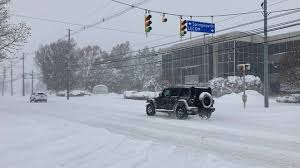
A powerful winter storm is set to unleash dangerous cold and intense lake-effect snowfall across New York tonight, with wind chills dropping as low as -20°F and blinding snowfall rates of 3 inches per hour. Forecasters warn that the combination of Arctic air, strong winds, and heavy snow bands will create whiteout conditions, impassable roads, and dangerously cold temperatures throughout the state.
The National Weather Service has issued Winter Storm Warnings and Wind Chill Advisories, cautioning residents that frostbite can occur in less than 10 minutes in these conditions.
Snowfall and Wind Chill Forecast
Meteorologists predict that lake-effect snow will intensify overnight, with some areas expecting over a foot of snow by morning. Winds gusting up to 40 mph will create blowing and drifting snow, reducing visibility and making travel treacherous.
- Lake-Effect Snowfall: Up to 3 inches per hour, with localized totals exceeding 12-18 inches
- Wind Chills: Feels-like temperatures as low as -20°F, posing a risk of frostbite and hypothermia
- Wind Gusts: Up to 40 mph, worsening visibility and road conditions
- Temperatures: Lows dropping into the single digits statewide
Regions Most Affected
Buffalo & Western NY: 12-18 inches of lake-effect snow, with whiteout conditions
Syracuse & Central NY: 8-12 inches, strong winds, and dangerously cold wind chills
Rochester & Finger Lakes: 6-10 inches, blowing snow will cause drifting on highways
Albany & Upstate NY: 4-8 inches, with subzero wind chills making travel hazardous
New York City & Hudson Valley: Less snow, but wind chills in the single digits
Travel Disruptions and Safety Concerns
Highways Becoming Impassable: I-90, I-81, and I-87 will see heavy snow accumulation and whiteout conditions
Road Closures Possible: Blowing and drifting snow will reduce visibility to near-zero at times
Flight Delays & Cancellations: Major disruptions expected at JFK, LaGuardia, and Buffalo Niagara International Airport
Power Outages Possible: High winds and heavy snow could cause downed power lines, leaving thousands without heat
How to Stay Safe During the Storm
✔ Limit Outdoor Exposure: Wind chills this low can cause frostbite in under 10 minutes
✔ Avoid Non-Essential Travel: Blowing snow and ice will make roads extremely dangerous
✔ Prepare for Power Outages: Have flashlights, extra blankets, and backup heat sources ready
✔ Dress in Layers: Wear insulated clothing, hats, gloves, and face coverings to protect against the cold
✔ Check on Vulnerable Neighbors: Ensure elderly and at-risk individuals have heat and supplies
When Will Conditions Improve?
The worst of the storm is expected overnight into early Thursday, with snowfall rates slowing by midday. However, cold temperatures will linger through the weekend, keeping roads slick and icy. Another storm system next week could bring additional snowfall to the region.
Residents are urged to stay informed through local news and weather alerts, as conditions may worsen rapidly. With extreme cold and near-blizzard conditions expected, officials are advising everyone to stay indoors and avoid unnecessary travel.