
Residents of American Samoa are being urged to prepare for a powerful storm system that is set to bring intense rainfall, gusty winds, and the threat of flash flooding over the next several days. The National Weather Service (NWS) in Pago Pago has issued urgent advisories, warning that the combination of relentless rain and strong winds could cause hazardous conditions across the region. The storm, driven by strong northwesterly winds, is expected to bring several inches of rain, with the potential for flash flooding in low-lying areas. Residents should take precautions now to secure their homes, avoid unnecessary travel, and stay updated on emergency alerts.
Storm Timeline: What to Expect Day by Day
The weather will start worsening on Friday, February 21, as heavy rain and thunderstorms move in. Wind speeds are forecasted to increase dramatically, reaching 30 to 40 mph, with stronger gusts possible. Visibility on the roads may be poor due to pounding rain, and localized flooding could make travel dangerous.
By Friday night, conditions will worsen, with continued downpours keeping roads slick and raising concerns about landslides in hilly areas. Winds will shift slightly from the north but remain strong, between 25 to 35 mph.
- Saturday, February 22, will bring some relief from the heaviest rains, but the region will still see numerous showers and breezy conditions throughout the day. While rain totals will be lower than on Friday, flooded areas may take time to drain, and standing water could create hazards.
- By Sunday, February 23, scattered showers will continue, but the worst of the storm will likely have passed. Temperatures will remain warm, with highs in the upper 80s°F (31°C) and lows in the upper 70s°F (25°C). Northeast winds will gradually weaken but will still be strong enough to impact outdoor activities.
Heading into Monday, February 24, and the rest of the week, American Samoa is expected to see mostly cloudy skies with scattered showers. While the immediate danger will subside, lingering rainfall and wet conditions could still pose problems for residents trying to recover from flooding.

Key Dangers and Safety Measures
With the worst of the storm hitting Friday and Saturday, residents need to take action now to stay safe.
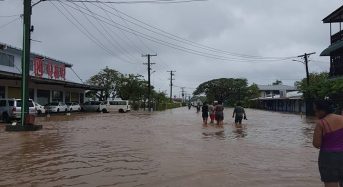
- Flash Floods: If you live in a low-lying or flood-prone area, make sure you have an evacuation plan. Never drive or walk through floodwaters—it only takes a few inches to sweep a person or vehicle away.
- Strong Winds: Secure outdoor furniture, trash bins, and anything that could become airborne. High winds can knock out power lines and cause structural damage, so be prepared for potential outages.
- Landslide Risk: If you live near steep hillsides, be aware of soil movement and report any signs of shifting ground immediately.
- Marine Hazards: Boaters and fishermen should avoid going out to sea, as high winds and rough waves could make conditions life-threatening.
Stay Informed and Prepared
This storm should not be taken lightly. Residents are urged to monitor updates from the National Weather Service, listen to local authorities, and avoid unnecessary risks. Have emergency supplies on hand, including food, water, flashlights, and extra batteries in case of power outages. American Samoa’s beautiful islands are no stranger to tropical weather, but with a storm of this magnitude, preparation is key to staying safe. Stay indoors when conditions worsen, look out for your neighbors, and take all necessary precautions. The worst may pass in a few days, but acting now could make all the difference.