San Diego on High Alert: Dangerous Rainfall, Flood Warnings, and What It Means for You
San Diego’s iconic sunny weather is about to take a dramatic detour as a powerful rainstorm makes its way into the area. Starting Thursday, the city will experience steady rainfall, strong enough to trigger flood warnings and cause problems for commuters, residents, and businesses alike. The National Weather Service has issued a Flood Watch for much of the region, urging people to stay alert and take precautions. This storm is expected to deliver some of the heaviest rain San Diego has seen in months, and its impact will be felt across highways, coastal neighborhoods, and flood-prone areas. Here’s what to expect and how to prepare.
Wednesday, February 12: Light Rain Before the Storm Intensifies
San Diego will get a small taste of what’s to come, as the day starts with a few light sprinkles and overcast skies. Temperatures will hover around 57°F (14°C), and while the rain won’t be too intense just yet, it’s a sign of bigger things ahead. As night falls, cloud cover will thicken, and the stage will be set for a more significant weather event.
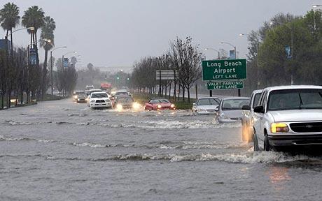
Thursday, February 13: Heavy Rain Brings Flood Warnings
By Thursday afternoon, the rain will ramp up, and it won’t be a drizzle. Steady showers will cover the city, with temperatures peaking around 59°F (15°C). The National Weather Service has highlighted areas with poor drainage as particularly vulnerable to flooding. If you’re planning to drive, be prepared for delays. Major highways like I-5 and I-8 could become hazardous due to water pooling on the roads. Commuters are advised to leave early or consider alternative routes. Driving through flooded streets is extremely dangerous—even shallow water can cause vehicles to lose control or stall.
Source: The New York Times
Friday, February 14: Lingering Showers Keep Conditions Wet
The rain won’t completely let up on Friday, with scattered showers expected throughout the day. Temperatures will remain cool, with a high near 60°F (16°C). Streets could still be waterlogged, especially in low-lying areas, making travel difficult. Coastal neighborhoods may also experience minor flooding as runoff flows toward the ocean. By Friday night, the rain is expected to begin tapering off, but slippery roads and debris—like fallen branches or loose rocks—could remain hazards for drivers. Pedestrians should also be cautious on wet sidewalks, as slick surfaces could lead to slips and falls.
Safety Tips to Keep in Mind
Avoid Flooded Roads: Don’t risk driving through standing water. Just six inches of water can stall a car or sweep it off the road.
Check Traffic Updates: If you need to drive, leave extra time and monitor road closures or detours.
Protect Your Property: Clear out gutters and downspouts to help prevent water buildup. Consider using sandbags if your home is in a flood-prone area.
Stay Informed: Keep your phone charged and stay tuned to local weather updates and emergency alerts.
What’s Next for San Diego
The weekend should bring a break from the rain, with drier skies expected by Saturday. However, with the ground already saturated, even a small amount of rainfall could trigger flooding or mudslides. For now, it’s all about preparation. Don’t underestimate the power of water—San Diego’s soil may be dry, but when it rains hard, the risks are real. Stay safe, stay aware, and take the warnings seriously.