
Nashville is bracing for an intense weather event that’s expected to bring heavy rainfall, flash flooding, and potentially hazardous travel conditions throughout the week. The National Weather Service has issued a Flood Watch for parts of the city, warning that low-lying areas, highways, and neighborhoods with poor drainage could face significant water accumulation. For residents, this means preparing for more than just wet commutes—it could be a week of slow traffic, waterlogged roads, and possible disruptions. Here’s an in-depth breakdown of what to expect over the next few days and how you can stay safe.
Tuesday, February 11: The Rain Begins
Tuesday sets the stage for the rest of the week, with a steady drizzle turning into heavier rain by late afternoon. Temperatures will reach a high of 45°F (7°C), creating a chilly, damp atmosphere. Streets and highways may already experience some minor ponding by evening, making it important for drivers to slow down and watch for standing water. Motorists heading home after work should leave extra time for their commute, as traffic will likely be slower on slick roads. Pedestrians should also tread carefully, as wet sidewalks could be slippery.
Wednesday, February 12: Warmer Temperatures, More Rain
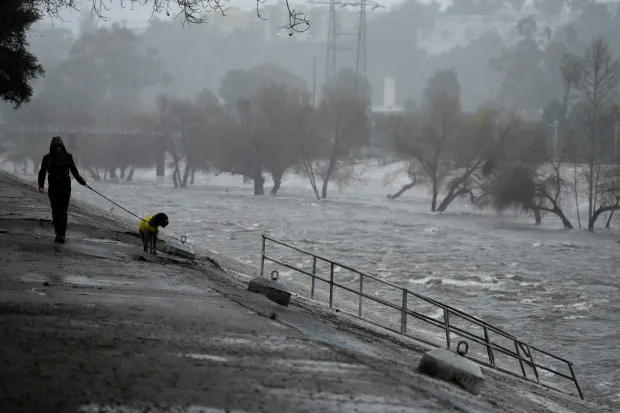
Expect a significant warm-up on Wednesday, with highs reaching 59°F (15°C). But with the warmer air comes more rain. Showers are forecast to pick up in intensity by mid-morning and last through the evening, leading to a higher risk of localized flooding in low-lying areas. If you live near creeks, rivers, or areas prone to water pooling, keep an eye out for flood alerts. Commuters, especially those using interstates like I-40 and I-65, should stay updated on traffic reports to avoid delays. The combination of heavy rain and poor drainage could lead to water covering sections of key roadways.

Thursday, February 13: Slick Roads and Residual Flooding
By Thursday, the rain will have eased, but its impact may linger. Morning commuters could encounter leftover slick spots on roads, especially in shaded areas where water hasn’t fully dried. Temperatures will cool again, with highs near 40°F (4°C). Even if the rain subsides, be cautious when driving or walking, as waterlogged ground could remain hazardous.
Weekend Warning: Potential Storms and Rapid Temperature Drop
The biggest risk comes on Saturday when a stronger storm system is expected to bring heavy downpours, strong winds, and possibly thunderstorms. The high will be near 60°F (16°C), but fast-moving storms could cause sudden flooding, especially in areas already soaked from earlier in the week. Isolated wind damage and power outages may occur, so residents should be prepared. By Sunday, temperatures will drop sharply to a high of 39°F (4°C) and a nighttime low of 18°F (-8°C). Any remaining moisture on roads or sidewalks could freeze, creating dangerous black ice.
Safety Tips for Navigating the Storm
- Stay Off Flooded Roads: Even a small amount of water can sweep your car away. Never attempt to drive through flooded areas, no matter how shallow the water seems.
- Keep Emergency Supplies Ready: Power outages are possible, so ensure you have flashlights, batteries, and a stock of food and water.
- Monitor Weather Alerts: Keep an eye on local news and emergency notifications. Flooding and storm conditions can change quickly.
- Secure Outdoor Items: If winds pick up, bring in patio furniture, trash cans, or other objects that could blow away.
Final Word
Nashville’s weather this week will be far from predictable. Heavy rain, fluctuating temperatures, and sudden storms could cause disruptions if residents aren’t ready. By staying informed and following safety tips, you can minimize the risks and keep your plans on track. Once the weekend clears up, drier skies will return, but for now, preparation is key. Stay safe, Nashville!