
Residents of Columbia County need to prepare for a dangerous weather event that is set to impact the area on Wednesday, March 5. Meteorologists are warning of severe thunderstorms, damaging winds, and the possibility of tornadoes, as a powerful storm system moves through Georgia. The National Weather Service has issued a Hazardous Weather Outlook, advising that conditions are highly favorable for destructive storms capable of bringing flash flooding, power outages, and property damage. Officials are urging everyone in Columbia County to take immediate precautions to ensure their safety.
What to Expect – Severe Weather Threats Explained
This approaching system is rapidly intensifying, fueled by warm Gulf air colliding with a strong cold front. The result? A dangerous setup that could bring multiple severe weather threats in just a few hours.
- Tornado Threat: Conditions are perfect for isolated tornadoes to form, especially in the afternoon and evening hours. Residents should have a safety plan in place and be ready to take cover at a moment’s notice.
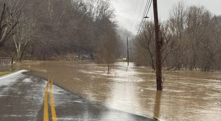
- Flash Flooding Risk: The storm could produce up to 3 inches of rain in just a few hours, overwhelming drainage systems and flooding roads. Low-lying areas will be especially vulnerable to rising water.
- Damaging Winds: Wind gusts could exceed 60 mph, strong enough to bring down trees, power lines, and cause structural damage. Power outages are expected.
- Frequent Lightning: Dangerous cloud-to-ground lightning strikes will increase the risk of house fires and injuries for anyone caught outside.

Forecast for Wednesday, March 5
- Morning: Cloudy with light showers. Winds will start picking up.
- Afternoon: Severe thunderstorms likely, with high winds and potential tornado development.
- Evening: Heavy rain expected, with flash flooding possible in multiple areas. Storms continue overnight.
How to Stay Safe Before, During, and After the Storm
With this dangerous storm system approaching, take these essential safety precautions:
- Stay Informed: Monitor weather alerts from the National Weather Service and local news. Tornado warnings may be issued with little notice, so be ready to act fast.
- Secure Your Property: Bring in or tie down outdoor furniture, trash cans, and loose objects that could become dangerous in high winds.
- Prepare for Power Outages: Charge your phone, have flashlights and extra batteries, and keep emergency supplies like food, water, and medications ready.
- Know Your Shelter Plan: Identify a safe space in your home, such as a basement or an interior room without windows, where you can take cover during a tornado warning.
- Avoid Flooded Roads: Never attempt to drive through floodwaters. Just six inches of moving water can knock a person down, and one foot of water can carry away a car.
What Happens Next?
While the storm is expected to weaken by early Thursday, lingering rain, strong winds, and potential power outages could still cause disruptions. Road closures and flood damage may take days to clear, so residents should be prepared for delays in emergency response and travel issues. This is a rapidly evolving situation, and weather experts stress that conditions could intensify with little warning. Officials are urging Columbia County residents to stay inside, remain vigilant, and follow all emergency instructions to stay safe. Be prepared, stay informed, and most importantly, stay safe, Columbia County.